
Ihosy topographic map
Interactive map
Click on the map to display elevation.
About this map
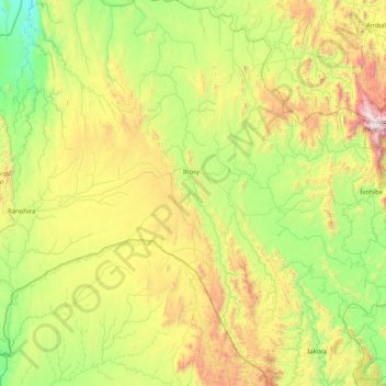
Name: Ihosy topographic map, elevation, terrain.
Location: Ihosy, Ihorombe, Province de Fianarantsoa, Madagascar (-23.23617 45.87832 -21.73513 46.38872)
Average elevation: 2,831 ft
Minimum elevation: 719 ft
Maximum elevation: 8,619 ft
Other topographic maps
Click on a map to view its topography, its elevation and its terrain.
Isalo National Park
Madagascar > Ihorombe > Ranohira
Isalo National Park, Ranohira, Ihorombe, Province de Fianarantsoa, Madagascar
Average elevation: 2,635 ft
Ivohibe
Madagascar > Ihorombe > Ivohibe
Ivohibe, Ihorombe, Province de Fianarantsoa, Madagascar
Average elevation: 2,480 ft