Geolocate

Toronto topographic map

Click on the map to display elevation.

About this map

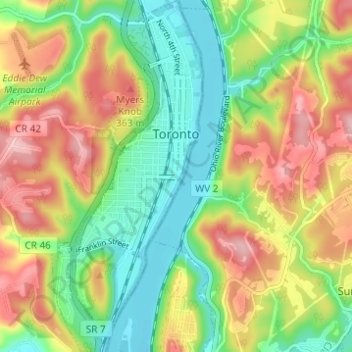
Name: Toronto topographic map, elevation, terrain.

Location: Toronto, Jefferson County, Ohio, United States (40.43647 -80.62282 40.48325 -80.59620)

Average elevation: 909 ft

Minimum elevation: 650 ft

Maximum elevation: 1,243 ft

Jefferson County trails, hiking, mountain biking, running and outdoor activities

Other topographic maps

Click on a map to view its topography, its elevation and its terrain.

Wolf Run

United States > Ohio > Jefferson County

Average elevation: 1,178 ft

Hammondsville

United States > Ohio > Jefferson County

Average elevation: 961 ft

Green Acres

United States > Ohio > Jefferson County

Average elevation: 1,073 ft

La Belle

United States > Ohio > Jefferson County > Steubenville

Average elevation: 876 ft

Beechwood

United States > Ohio > Jefferson County > Wintersville

Average elevation: 1,142 ft

Gear up for your next adventure:

📚Navigation Handbooks - Master the art of reading topographic maps and using a compass
🛶Inflatable Kayak - Portable kayak for rivers, lakes, and expeditions
😴Insulated Sleeping Pads - Compact and warm pads for high-elevation camping
🧦Hiking Socks - Comfortable socks to prevent blisters on long hikes
💧Water Filtration Bottles - Safely drink from streams and lakes while exploring

As an Amazon Associate, this site earns from qualifying purchases at no extra cost to you.