Geolocate

Milton topographic map

Click on the map to display elevation.

About this map

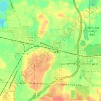
Name: Milton topographic map, elevation, terrain.

Location: Milton, Rock County, Wisconsin, 53563, United States (42.75767 -88.97868 42.79446 -88.90602)

Average elevation: 889 ft

Minimum elevation: 807 ft

Maximum elevation: 965 ft

Rock County trails, hiking, mountain biking, running and outdoor activities

Other topographic maps

Click on a map to view its topography, its elevation and its terrain.

Lima Center

United States > Wisconsin > Rock County

Average elevation: 899 ft

Foxhollow

United States > Wisconsin > Rock County > Town of Turtle

Average elevation: 912 ft

Avalon

United States > Wisconsin > Rock County

Average elevation: 948 ft

Tiffany

United States > Wisconsin > Rock County > Town of Turtle

Average elevation: 860 ft

Cainville

United States > Wisconsin > Rock County

Average elevation: 932 ft

Mount Zion

United States > Wisconsin > Rock County

Average elevation: 938 ft

Gear up for your next adventure:

👟Men's Trail Runners - Lightweight footwear for fast-paced exploration and light hiking
🚁Photography Drones - Capture stunning aerial views of landforms and topography
📡GPS Antenna Upgrade - Enhance GPS reception in remote terrain
Backpacking Tents - Weight-optimized shelters for multi-day topographic surveys
🧭Pro Hiking Compasses - High-accuracy liquid-filled compasses for topographic orientation

As an Amazon Associate, this site earns from qualifying purchases at no extra cost to you.