
Coraopolis topographic map
Click on the map to display elevation.
Coraopolis
Coraopolis is located west of Pittsburgh along the Ohio River and to the east of the Pittsburgh International Airport. The borough has steep topography, numerous brick streets and many large, old houses. Dick's Sporting Goods is headquartered in Coraopolis, as is the American Bridge Company.
About this map
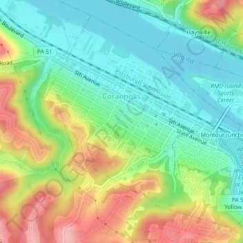
Name: Coraopolis topographic map, elevation, terrain.
Average elevation: 863 ft
Minimum elevation: 682 ft
Maximum elevation: 1,165 ft
Allegheny County trails, hiking, mountain biking, running and outdoor activities
Other topographic maps
Click on a map to view its topography, its elevation and its terrain.
Glenshaw
United States > Pennsylvania > Allegheny County > Shaler Township
Average elevation: 1,024 ft
Keown Station
United States > Pennsylvania > Allegheny County > Ross Township
Average elevation: 1,129 ft
Ruthfred Acres
United States > Pennsylvania > Allegheny County > Bethel Park
Average elevation: 1,142 ft
Monroe Heights
United States > Pennsylvania > Allegheny County > Monroeville
Average elevation: 1,083 ft
Champion
United States > Pennsylvania > Allegheny County > North Fayette Township
Average elevation: 1,181 ft
Tortilla Flats
United States > Pennsylvania > Allegheny County > Sewickley Heights
Average elevation: 1,093 ft
Mustard
United States > Pennsylvania > Allegheny County > Elizabeth Township
Average elevation: 1,017 ft
Linhart
United States > Pennsylvania > Allegheny County > Wilkins Township
Average elevation: 1,030 ft
Beechmont
United States > Pennsylvania > Allegheny County > Collier Township
Average elevation: 1,076 ft
Coraopolis Heights
United States > Pennsylvania > Allegheny County > Findlay Township
Average elevation: 1,050 ft
Central Highlands
United States > Pennsylvania > Allegheny County > Elizabeth Township
Average elevation: 1,073 ft
Sturgeon
United States > Pennsylvania > Allegheny County > North Fayette Township
Average elevation: 1,096 ft
Perrysville
United States > Pennsylvania > Allegheny County > Ross Township
Average elevation: 1,119 ft
Gibsonia
United States > Pennsylvania > Allegheny County > Richland Township
Average elevation: 1,142 ft
Highland Park Reservoir No. 2
United States > Pennsylvania > Allegheny County > Pittsburgh
Average elevation: 902 ft
Allison Park
United States > Pennsylvania > Allegheny County > Hampton Township
Average elevation: 1,063 ft
Neville Island
United States > Pennsylvania > Allegheny County > Neville Township
Average elevation: 948 ft
Observatory Hill
United States > Pennsylvania > Allegheny County > Pittsburgh
Average elevation: 1,047 ft
Cochrans Mill
United States > Pennsylvania > Allegheny County > Jefferson Hills
Average elevation: 1,020 ft
Allegheny River Lock and Dam No. 2
United States > Pennsylvania > Allegheny County > O'Hara Township
Average elevation: 879 ft
Lovedale
United States > Pennsylvania > Allegheny County > Elizabeth Township
Average elevation: 978 ft
Stoneybrooke Woods
United States > Pennsylvania > Allegheny County > Cheswick
Average elevation: 928 ft