Geolocate

Concan topographic map

Click on the map to display elevation.

About this map

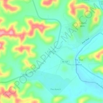
Name: Concan topographic map, elevation, terrain.

Location: Concan, Uvalde County, Texas, 78838, United States (29.48044 -99.74263 29.52044 -99.70263)

Average elevation: 1,375 ft

Minimum elevation: 1,211 ft

Maximum elevation: 1,739 ft

Uvalde County trails, hiking, mountain biking, running and outdoor activities

Other topographic maps

Click on a map to view its topography, its elevation and its terrain.

Garner State Park

United States > Texas > Uvalde County > Concan

Average elevation: 1,496 ft

Garner State Park

United States > Texas > Uvalde County > Concan

Average elevation: 1,496 ft

Gear up for your next adventure:

👖Convertible Hiking Pants - Versatile zip-off pants for changing altitudes and temperatures
🔭Compact Binoculars - HD vision for scouting terrain and identifying distant landmarks
Camping Coffee Makers - Enjoy premium coffee at the summit or campsite
🚗GPS Dash Cams - Record your scenic drives through mountain passes and canyons
🩳Quick‑Dry Hiking Shorts - Comfortable and quick‑dry shorts for summer hiking

As an Amazon Associate, this site earns from qualifying purchases at no extra cost to you.