Geolocate

Sabinal topographic map

Click on the map to display elevation.

About this map

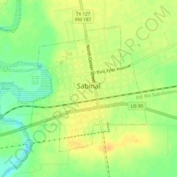
Name: Sabinal topographic map, elevation, terrain.

Location: Sabinal, Uvalde County, Texas, 78881, United States (29.31072 -99.49047 29.33118 -99.45753)

Average elevation: 948 ft

Minimum elevation: 889 ft

Maximum elevation: 988 ft

Uvalde County trails, hiking, mountain biking, running and outdoor activities

Other topographic maps

Click on a map to view its topography, its elevation and its terrain.

Blue Mountain

United States > Texas > Uvalde County

Average elevation: 1,017 ft

Onion Creek

United States > Texas > Uvalde County

Average elevation: 1,339 ft

Reagan Wells

United States > Texas > Uvalde County

Average elevation: 1,585 ft

Montell

United States > Texas > Uvalde County

Average elevation: 1,329 ft

Laguna

United States > Texas > Uvalde County

Average elevation: 1,171 ft

Uvalde Estates

United States > Texas > Uvalde County

Average elevation: 948 ft

Gear up for your next adventure:

🧦Hiking Socks - Comfortable socks to prevent blisters on long hikes
🪶Camp Gear Gift Set - Perfect gift bundle for outdoor fans
🪑Ultralight Camp Chairs - Portable seating for resting after a long day of mapping
🚁Photography Drones - Capture stunning aerial views of landforms and topography
🧤Hiking Gloves - Protective gloves for rugged trails

As an Amazon Associate, this site earns from qualifying purchases at no extra cost to you.