Geolocate

Bramcote topographic map

Click on the map to display elevation.

About this map

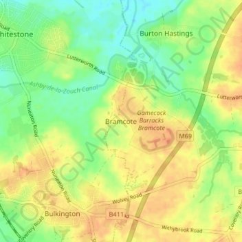
Name: Bramcote topographic map, elevation, terrain.

Location: Bramcote, Rugby, Warwickshire, England, CV11 6QX, United Kingdom (52.47101 -1.42719 52.51101 -1.38719)

Average elevation: 344 ft

Minimum elevation: 285 ft

Maximum elevation: 397 ft

Other topographic maps

Click on a map to view its topography, its elevation and its terrain.

Grandborough CP

United Kingdom > England > Warwickshire > Rugby

Average elevation: 302 ft

Cawston

United Kingdom > England > Warwickshire > Rugby

Average elevation: 358 ft

Burton Hastings CP

United Kingdom > England > Warwickshire > Rugby

Average elevation: 335 ft

Thurlaston CP

United Kingdom > England > Warwickshire > Rugby

Average elevation: 322 ft

Birdingbury CP

United Kingdom > England > Warwickshire > Rugby

Average elevation: 269 ft

Long Lawford

United Kingdom > England > Warwickshire > Rugby

Average elevation: 331 ft

Dunchurch

United Kingdom > England > Warwickshire > Rugby

Average elevation: 335 ft

Churchover CP

United Kingdom > England > Warwickshire > Rugby

Average elevation: 377 ft

King's Newnham CP

United Kingdom > England > Warwickshire > Rugby

Average elevation: 285 ft

Brinklow CP

United Kingdom > England > Warwickshire > Rugby

Average elevation: 295 ft

Pailton CP

United Kingdom > England > Warwickshire > Rugby

Average elevation: 384 ft

Ansty CP

United Kingdom > England > Warwickshire > Rugby

Average elevation: 299 ft

Draycote Water

United Kingdom > England > Warwickshire > Rugby > Draycote

Average elevation: 302 ft

Binley Woods CP

United Kingdom > England > Warwickshire > Rugby

Average elevation: 282 ft

Withybrook CP

United Kingdom > England > Warwickshire > Rugby

Average elevation: 377 ft

Wolvey CP

United Kingdom > England > Warwickshire > Rugby

Average elevation: 371 ft

Dunchurch

United Kingdom > England > Warwickshire > Rugby

Average elevation: 335 ft

Frankton CP

United Kingdom > England > Warwickshire > Rugby > Frankton CP

Average elevation: 312 ft

Wibtoft CP

United Kingdom > England > Warwickshire > Rugby > Wibtoft CP

Average elevation: 407 ft

Church Lawford CP

United Kingdom > England > Warwickshire > Rugby

Average elevation: 322 ft

Thurlaston CP

United Kingdom > England > Warwickshire > Rugby

Average elevation: 322 ft

Monks Kirby CP

United Kingdom > England > Warwickshire > Rugby

Average elevation: 384 ft

Harborough Magna CP

United Kingdom > England > Warwickshire > Rugby

Average elevation: 348 ft

Churchover CP

United Kingdom > England > Warwickshire > Rugby

Average elevation: 377 ft

Gear up for your next adventure:

Backpacking Tent - Lightweight and durable tent for multi‑day hikes
🔊Portable Camp Speaker - Music and alerts at camp
🧺Microfiber Travel Towels - Compact and fast-drying towels for trail use
Backpacking Tents - Weight-optimized shelters for multi-day topographic surveys
📡Handheld GPS Device - Reliable handheld GPS for outdoor navigation

As an Amazon Associate, this site earns from qualifying purchases at no extra cost to you.