Geolocate

Kingsbridge topographic map

Click on the map to display elevation.

About this map

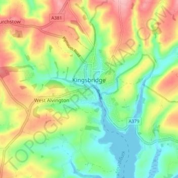
Name: Kingsbridge topographic map, elevation, terrain.

Location: Kingsbridge, South Hams, Devon, England, United Kingdom (50.26122 -3.78809 50.30411 -3.75411)

Average elevation: 174 ft

Minimum elevation: -23 ft

Maximum elevation: 407 ft

Other topographic maps

Click on a map to view its topography, its elevation and its terrain.

Penquit

United Kingdom > England > Devon > South Hams > Ermington

Average elevation: 217 ft

Weston

United Kingdom > England > Devon > South Hams > Berry Pomeroy

Average elevation: 194 ft

Gear up for your next adventure:

🩹Survival Bandages - High‑quality bandages for emergencies
🔊Portable Camp Speaker - Music and alerts at camp
🚗GPS Dash Cams - Record your scenic drives through mountain passes and canyons
GPS Sports Watch - GPS watch for running, hiking and training
🥾Hiking Shoes - Durable and comfortable shoes for trail hiking

As an Amazon Associate, this site earns from qualifying purchases at no extra cost to you.