
Make a donation
Gear up for your next adventure:
As an Amazon Associate, this site earns from qualifying purchases at no extra cost to you.
Bandorf topographic map
Click on the map to display elevation.
Make a donation
Gear up for your next adventure:
As an Amazon Associate, this site earns from qualifying purchases at no extra cost to you.
About this map
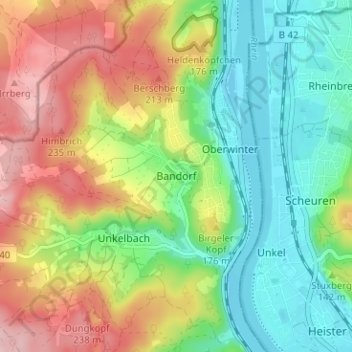
Name: Bandorf topographic map, elevation, terrain.
Average elevation: 430 ft
Minimum elevation: 167 ft
Maximum elevation: 814 ft
Make a donation
Gear up for your next adventure:
As an Amazon Associate, this site earns from qualifying purchases at no extra cost to you.
Other topographic maps
Click on a map to view its topography, its elevation and its terrain.
Kripp
Deutschland > Rheinland-Pfalz > Landkreis Ahrweiler > Remagen
Kripp teilt sich in das Ober- und Unterdorf, unterschieden nach der Höhenlage am Rheinufer. Sein Wahrzeichen ist der Kripper Wasserturm (erbaut 1904), der sich weithin sichtbar über die Gärten erhebt und unter Denkmalschutz gestellt wurde.
Average elevation: 246 ft
Rodderberg
Deutschland > Rheinland-Pfalz > Landkreis Ahrweiler > Remagen > Rolandswerth
Der Rodderberg liegt direkt oberhalb vom nördlichen Ausgang des Mittelrheintals. Zusammen mit dem fast direkt gegenüberliegenden Drachenfels verengt er das Rheintal. Diese Engstelle bildet die Südgrenze der Kölner Bucht, während sich südlich dieser Engstelle die kleine Talverbreiterung von Oberwinter…
Average elevation: 348 ft
Dungkopfsee
Deutschland > Rheinland-Pfalz > Landkreis Ahrweiler > Remagen > Unkelbach
Average elevation: 581 ft