
Make a donation
Gear up for your next adventure:
As an Amazon Associate, this site earns from qualifying purchases at no extra cost to you.
Kripp topographic map
Click on the map to display elevation.
Make a donation
Gear up for your next adventure:
As an Amazon Associate, this site earns from qualifying purchases at no extra cost to you.
Kripp
Kripp teilt sich in das Ober- und Unterdorf, unterschieden nach der Höhenlage am Rheinufer. Sein Wahrzeichen ist der Kripper Wasserturm (erbaut 1904), der sich weithin sichtbar über die Gärten erhebt und unter Denkmalschutz gestellt wurde.
Make a donation
Gear up for your next adventure:
As an Amazon Associate, this site earns from qualifying purchases at no extra cost to you.
About this map
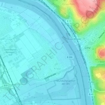
Name: Kripp topographic map, elevation, terrain.
Average elevation: 246 ft
Minimum elevation: 171 ft
Maximum elevation: 653 ft
Make a donation
Gear up for your next adventure:
As an Amazon Associate, this site earns from qualifying purchases at no extra cost to you.
Other topographic maps
Click on a map to view its topography, its elevation and its terrain.
Rodderberg
Deutschland > Rheinland-Pfalz > Landkreis Ahrweiler > Remagen > Rolandswerth
Der Rodderberg liegt direkt oberhalb vom nördlichen Ausgang des Mittelrheintals. Zusammen mit dem fast direkt gegenüberliegenden Drachenfels verengt er das Rheintal. Diese Engstelle bildet die Südgrenze der Kölner Bucht, während sich südlich dieser Engstelle die kleine Talverbreiterung von Oberwinter…
Average elevation: 348 ft
Oberwinter
Deutschland > Rheinland-Pfalz > Landkreis Ahrweiler > Remagen > Oberwinter
Oberwinter liegt am nördlichen Mittelrhein am linken Ufer gegenüber der Ortsgemeinde Rheinbreitbach. Der Ort lässt sich naturräumlich der Honnefer Talweitung zuordnen, die sich linksrheinisch durch ein bis über 100 m hohes Steilufer kennzeichnet, dem rechtsrheinisch ein wesentlich breiterer, halbmondartig…
Average elevation: 394 ft
Rolandswerth
Deutschland > Rheinland-Pfalz > Landkreis Ahrweiler > Remagen
Rolandswerth erstreckt sich am linken Rheinufer zwischen Mehlem im Nordwesten und Rolandseck im Süden, zu denen entlang der Bundesstraße 9 ein fließender Übergang besteht. Die Ortschaft umfasst Höhenlagen zwischen 54 m ü. NHN und 105 m ü. NHN, wobei sie sich nach Süden deutlich verjüngt.…
Average elevation: 348 ft
Make a donation
Gear up for your next adventure:
As an Amazon Associate, this site earns from qualifying purchases at no extra cost to you.
Make a donation
Gear up for your next adventure:
As an Amazon Associate, this site earns from qualifying purchases at no extra cost to you.
Dungkopfsee
Deutschland > Rheinland-Pfalz > Landkreis Ahrweiler > Remagen > Unkelbach
Average elevation: 581 ft