
Sulmona topographic map
Click on the map to display elevation.
About this map
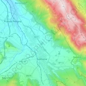
Name: Sulmona topographic map, elevation, terrain.
Location: Sulmona, L'Aquila, 67039, Italy (42.01104 13.86318 42.12684 13.98013)
Average elevation: 2,320 ft
Minimum elevation: 866 ft
Maximum elevation: 6,749 ft
Other topographic maps
Click on a map to view its topography, its elevation and its terrain.
Apennine Mountains
A separate branch, the Apuan Alps, goes southwest, bordering the coast south of La Spezia. Whether they are to be considered part of the Apennines is a matter of opinion; certainly, they are part of the Apennine System. Topographically only the valley of the River Serchio, which running parallel to the coast…
Average elevation: 5,692 ft
Rocca Calascio
At an elevation of around 1,460 metres (4,790 ft), the castle is the highest fortress in the Apennines. Built of stone and masonry exclusively for military purposes and intended only to accommodate troops and never as a residence for nobles, the fortress overlooks the Plain of Navelli at one of the highest…
Average elevation: 3,842 ft
Rocca Calascio
At an elevation of 1,512 metres (4,961 ft), the castle is the highest fortress in the Apennines. Built of stone and masonry exclusively for military purposes and intended only to accommodate troops and never as residence for nobles, the fortress overlooks the Plain of Navelli at one of the highest points in…
Average elevation: 3,842 ft