Geolocate

Lemgo topographic map

Click on the map to display elevation.

About this map

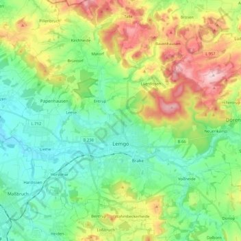
Name: Lemgo topographic map, elevation, terrain.

Location: Lemgo, Kreis Lippe, North Rhine-Westphalia, 32657, Germany (51.97586 8.80576 52.10440 8.99717)

Average elevation: 568 ft

Minimum elevation: 266 ft

Maximum elevation: 1,184 ft

Other topographic maps

Click on a map to view its topography, its elevation and its terrain.

Horn

Germany > North Rhine-Westphalia > Kreis Lippe

Average elevation: 837 ft

Gear up for your next adventure:

🛡️Bear Spray Outdoor - Protection in bear country hikes
🛶Inflatable Kayak - Portable kayak for rivers, lakes, and expeditions
🔋Rechargeable Batteries - Power up your outdoor devices
🛏️Cold Weather Sleeping Bag - Warm sleeping bag for cold conditions
🛰️Satellite Messengers - Emergency SOS and two-way messaging for off-grid adventures

As an Amazon Associate, this site earns from qualifying purchases at no extra cost to you.