Geolocate

Horn topographic map

Click on the map to display elevation.

About this map

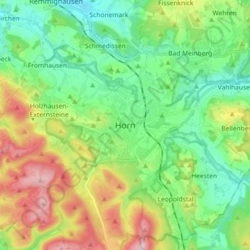
Name: Horn topographic map, elevation, terrain.

Location: Horn, Horn-Bad Meinberg, Kreis Lippe, North Rhine-Westphalia, 32805, Germany (51.83276 8.90538 51.91276 8.98538)

Average elevation: 837 ft

Minimum elevation: 492 ft

Maximum elevation: 1,529 ft

Other topographic maps

Click on a map to view its topography, its elevation and its terrain.

Detmold

Germany > North Rhine-Westphalia > Kreis Lippe

Average elevation: 663 ft

32832

Germany > North Rhine-Westphalia > Kreis Lippe > Augustdorf

Average elevation: 666 ft

Lage

Germany > North Rhine-Westphalia > Kreis Lippe

Average elevation: 456 ft

Blomberg

Germany > North Rhine-Westphalia > Kreis Lippe

Average elevation: 673 ft

Lemgo

Germany > North Rhine-Westphalia > Kreis Lippe

Average elevation: 568 ft

Gear up for your next adventure:

🧢Sun Protection Hats - Wide-brimmed and UPF-rated hats for high-altitude sun safety
🪄Magnetic Compass - Accurate compass for navigation
❄️Traction Cleats - Prevent slips on icy trails during winter hikes
🎒Day Hiking Backpack - Lightweight backpack perfect for day trips and outdoor adventures
🔥Camping Stove - Portable stove for camping and backcountry cooking

As an Amazon Associate, this site earns from qualifying purchases at no extra cost to you.