Geolocate

Isa topographic map

Click on the map to display elevation.

About this map

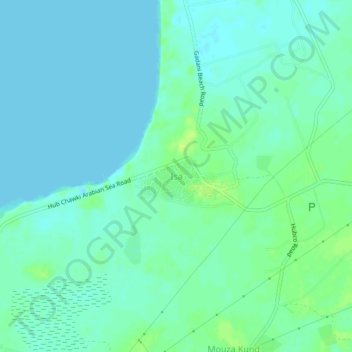
Name: Isa topographic map, elevation, terrain.

Location: Isa, Lasbela District, Balochistan, Pakistan (24.92806 66.68483 24.96806 66.72483)

Average elevation: 16 ft

Minimum elevation: -7 ft

Maximum elevation: 46 ft

Other topographic maps

Click on a map to view its topography, its elevation and its terrain.

Chagai District

Pakistan > Balochistan

Average elevation: 3,015 ft

Quetta City Tehsil

Pakistan > Balochistan > Quetta District

Average elevation: 6,499 ft

Quetta District

Pakistan > Balochistan

Average elevation: 5,072 ft

Hanna Lake

Pakistan > Balochistan > Quetta

Average elevation: 6,421 ft

Khuzdar Tehsil

Pakistan > Balochistan > Khuzdar District

Average elevation: 3,232 ft

Ziarat Park

Pakistan > Balochistan > Quetta

Average elevation: 5,505 ft

Gear up for your next adventure:

🚗GPS Dash Cams - Record your scenic drives through mountain passes and canyons
🧦Merino Wool Socks - Moisture-wicking, blister-preventing socks for long treks
🪶Compact Camp Shovel - Folding shovel for campsite tasks
🧯Portable Fire Pit - Compact fire pit for camping spots
🧦Hiking Socks - Comfortable socks to prevent blisters on long hikes

As an Amazon Associate, this site earns from qualifying purchases at no extra cost to you.