
Make a donation
Gear up for your next adventure:
As an Amazon Associate, this site earns from qualifying purchases at no extra cost to you.
Calistoga topographic map
Click on the map to display elevation.
Make a donation
Gear up for your next adventure:
As an Amazon Associate, this site earns from qualifying purchases at no extra cost to you.
About this map
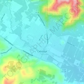
Name: Calistoga topographic map, elevation, terrain.
Location: Calistoga, Napa County, California, 94515, United States (38.56792 -122.60402 38.59807 -122.55484)
Average elevation: 525 ft
Minimum elevation: 312 ft
Maximum elevation: 1,332 ft
Napa County trails, hiking, mountain biking, running and outdoor activities
Make a donation
Gear up for your next adventure:
As an Amazon Associate, this site earns from qualifying purchases at no extra cost to you.
Other topographic maps
Click on a map to view its topography, its elevation and its terrain.
Napa Soda Springs
United States > California > Napa County > Napa Soda Springs
Average elevation: 899 ft
Make a donation
Gear up for your next adventure:
As an Amazon Associate, this site earns from qualifying purchases at no extra cost to you.
Make a donation
Gear up for your next adventure:
As an Amazon Associate, this site earns from qualifying purchases at no extra cost to you.
Enchanted Hills
United States > California > Napa County > Enchanted Hills
Average elevation: 1,467 ft