Geolocate

Locri topographic map

Click on the map to display elevation.

About this map

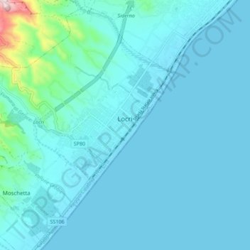
Name: Locri topographic map, elevation, terrain.

Location: Locri, Reggio Calabria, Calabria, 89044, Italy (38.20527 16.19790 38.26840 16.28209)

Average elevation: 92 ft

Minimum elevation: 0 ft

Maximum elevation: 1,079 ft

Other topographic maps

Click on a map to view its topography, its elevation and its terrain.

Riace Marina

Italy > Calabria > Reggio Calabria

Average elevation: 118 ft

Calamaci

Italy > Calabria > Reggio Calabria > Fossato

Average elevation: 2,346 ft

Mandorleto

Italy > Calabria > Reggio Calabria > Locri > Moschetta

Average elevation: 62 ft

Gear up for your next adventure:

📻Weather Alert Radios - Stay informed of storm risks while off-the-grid
🧯Emergency Survival Kit - All‑in‑one survival essentials for the backcountry
🥇GPS Hiking Watch - Multi‑sport GPS watch with navigation and trail tracking
👟Men's Trail Runners - Lightweight footwear for fast-paced exploration and light hiking
🩳Quick‑Dry Hiking Shorts - Comfortable and quick‑dry shorts for summer hiking

As an Amazon Associate, this site earns from qualifying purchases at no extra cost to you.