Geolocate

Lower Panaga topographic map

Click on the map to display elevation.

About this map

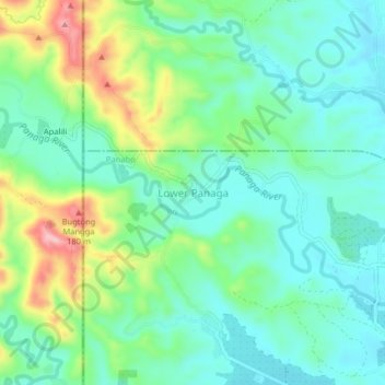
Name: Lower Panaga topographic map, elevation, terrain.

Location: Lower Panaga, Davao del Norte, Davao Region, 8105, Philippines (7.42654 125.54152 7.46654 125.58152)

Average elevation: 262 ft

Minimum elevation: 102 ft

Maximum elevation: 656 ft

Other topographic maps

Click on a map to view its topography, its elevation and its terrain.

Saug River

Philippines > Davao del Norte

Average elevation: 440 ft

Kapalong

Philippines > Davao del Norte

Average elevation: 738 ft

Hijo River

Philippines > Davao del Norte > Apokon

Average elevation: 154 ft

Gear up for your next adventure:

🛰️Handheld GPS Units - Professional satellite navigators for precise backcountry mapping
🦶Carbon Trekking Poles - Reduce knee impact on steep descents with ultra-light poles
🔋Solar Power Banks - Keep your GPS and phone charged in remote wilderness areas
🪶Trail Camera - Capture wildlife on your hikes
🏫Relief Map Kits - Hands-on tools for teaching landforms and elevation

As an Amazon Associate, this site earns from qualifying purchases at no extra cost to you.