
Nant topographic map
Click on the map to display elevation.
Nant
Le Causse Bégon est un élément méridional du Causse Noir ; son versant sud surplombe le bourg de Nant au Roc Nantais (altitude : 808 m).
About this map
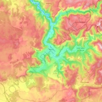
Name: Nant topographic map, elevation, terrain.
Average elevation: 2,441 ft
Minimum elevation: 1,404 ft
Maximum elevation: 3,327 ft
Other topographic maps
Click on a map to view its topography, its elevation and its terrain.
Barrage de Castelnau-Lassouts
France > Occitanie > Aveyron > Lassouts > Le Soulié
Le barrage de Castelnau-Lassouts est un barrage hydroélectrique situé dans le quart nord-est du département de l'Aveyron, sur le Lot, le plus long affluent de la Garonne. Il est implanté à 412 mètres d'altitude entre les communes de Castelnau-de-Mandailles et Lassouts, au lieu-dit las Combes.
Average elevation: 1,614 ft
Aubrac
France > Occitanie > Aveyron > Saint-Chély-d'Aubrac
Situé à une altitude d'environ 1 310 mètres dans la partie sommitale du plateau d'Aubrac, le village d'Aubrac est le plus élevé du département de l'Aveyron et un des plus élevés du Massif central. Le climat montagnard, sous influence océanique, y est rude et les longs hivers apportent froid intense et…
Average elevation: 4,206 ft
Le Nayrac
France > Occitanie > Aveyron > Le Nayrac > Le Nayrac
Le Lot prend sa source à 1272 m d’altitude sur la montagne du Goulet (nord du Mont Lozère), dans la commune de Cubières (48), et se jette dans la Garonne à Monheurt (47), après avoir parcouru 484 km et traversé 129 communes.
Average elevation: 2,159 ft
Gages le Haut
France > Occitanie > Aveyron > Montrozier > Gages-Montrozier
Average elevation: 1,955 ft
Falguières
France > Occitanie > Aveyron > Conques-en-Rouergue > Saint-Cyprien-sur-Dourdou
Average elevation: 1,299 ft
Lac de Maury
France > Occitanie > Aveyron > Saint-Amans-des-Cots
Le lac de Maury se situe à 586 mètres d'altitude en région Occitanie, dans le nord du département de l'Aveyron, en Viadène, sur le territoire des communes de Saint-Amans-des-Cots et Florentin-la-Capelle, et de Montpeyroux pour une faible partie amont de la branche de la Selves.
Average elevation: 2,126 ft
Conques Faubourg
France > Occitanie > Aveyron > Conques-en-Rouergue > Conques
Average elevation: 1,407 ft