Geolocate

Midway topographic map

Click on the map to display elevation.

About this map

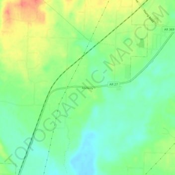
Name: Midway topographic map, elevation, terrain.

Location: Midway, Howard County, Arkansas, United States (33.88150 -93.91046 33.92150 -93.87046)

Average elevation: 344 ft

Minimum elevation: 272 ft

Maximum elevation: 449 ft

Howard County trails, hiking, mountain biking, running and outdoor activities

Other topographic maps

Click on a map to view its topography, its elevation and its terrain.

Tollette

United States > Arkansas > Howard County

Average elevation: 331 ft

Nashville

United States > Arkansas > Howard County

Average elevation: 420 ft

Gear up for your next adventure:

🔥Fast-Boil Camping Stoves - Efficient cooking systems for quick trail meals
📚USA Hiking Guide Books - Top trail guides and map books
🧭Compass with Lanyard - Easy‑carry compass for navigation
🧦Merino Wool Socks - Moisture-wicking, blister-preventing socks for long treks
🧷Carabiner Set - Durable clips for gear attachment

As an Amazon Associate, this site earns from qualifying purchases at no extra cost to you.