Walnut Grove topographic map
Interactive map
Click on the map to display elevation.
About this map
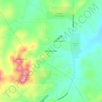
Name: Walnut Grove topographic map, elevation, terrain.
Location: Walnut Grove, Kendall County, Texas, United States (29.84827 -98.75475 29.88827 -98.71475)
Average elevation: 1,493 ft
Minimum elevation: 1,299 ft
Maximum elevation: 1,864 ft
Other topographic maps
Click on a map to view its topography, its elevation and its terrain.
Boerne
United States > Texas > Kendall County
Boerne, Kendall County, Texas, United States
Average elevation: 1,526 ft
Kreutzberg
United States > Texas > Kendall County
Kreutzberg, Kendall County, Texas, United States
Average elevation: 1,398 ft
Boerne
United States > Texas > Kendall County
Boerne, Kendall County, Texas, United States
Average elevation: 1,526 ft
Bergheim
United States > Texas > Kendall County
Bergheim, Kendall County, Texas, 78004, United States
Average elevation: 1,375 ft
Waring
United States > Texas > Kendall County
Waring, Kendall County, Texas, 78074, United States
Average elevation: 1,394 ft
Nelson City
United States > Texas > Kendall County
Nelson City, Kendall County, Texas, United States
Average elevation: 1,591 ft
Comfort
United States > Texas > Kendall County
Comfort, Kendall County, Texas, 70813, United States
Average elevation: 1,499 ft