
Alviso topographic map
Click on the map to display elevation.
About this map
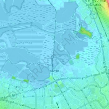
Name: Alviso topographic map, elevation, terrain.
Average elevation: 10 ft
Minimum elevation: -23 ft
Maximum elevation: 236 ft
Santa Clara County trails, hiking, mountain biking, running and outdoor activities
Other topographic maps
Click on a map to view its topography, its elevation and its terrain.
Sierra Vista Open Space Preserve
United States > California > Santa Clara County > San Jose
Average elevation: 1,588 ft
Martial Cottle Park
United States > California > Santa Clara County > San Jose
Average elevation: 171 ft