Geolocate

Denver topographic map

Click on the map to display elevation.

About this map

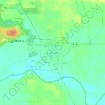
Name: Denver topographic map, elevation, terrain.

Location: Denver, Miami County, Indiana, United States (40.85870 -86.08432 40.86923 -86.07188)

Average elevation: 719 ft

Minimum elevation: 669 ft

Maximum elevation: 814 ft

Miami County trails, hiking, mountain biking, running and outdoor activities

Other topographic maps

Click on a map to view its topography, its elevation and its terrain.

Erie

United States > Indiana > Miami County

Average elevation: 784 ft

Miami

United States > Indiana > Miami County

Average elevation: 807 ft

Gear up for your next adventure:

🌡️Handheld Weather Meters - Measure wind, temp, and pressure for safe mountain travel
🪶Compact Camp Shovel - Folding shovel for campsite tasks
🏫Relief Map Kits - Hands-on tools for teaching landforms and elevation
🔌USB Car Charger - Car charger for on‑the‑go power needs
🚗GPS Dash Cams - Record your scenic drives through mountain passes and canyons

As an Amazon Associate, this site earns from qualifying purchases at no extra cost to you.