Geolocate

Erith topographic map

Click on the map to display elevation.

About this map

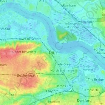
Name: Erith topographic map, elevation, terrain.

Location: Erith, London, Greater London, England, DA8 1SP, United Kingdom (51.44082 0.13923 51.52082 0.21923)

Average elevation: 56 ft

Minimum elevation: -26 ft

Maximum elevation: 240 ft

Other topographic maps

Click on a map to view its topography, its elevation and its terrain.

London

United Kingdom > England > London

Average elevation: 253 ft

Pool River

United Kingdom > England > London

Average elevation: 118 ft

Hackney Marshes

United Kingdom > England > London

Average elevation: 33 ft

Harmondsworth Moor

United Kingdom > England > London

Average elevation: 85 ft

Hampstead Heath

United Kingdom > England > London

Average elevation: 308 ft

London

United Kingdom > England > London

Average elevation: 69 ft

Kensington Gardens

United Kingdom > England > London

Average elevation: 82 ft

Hampstead No. 1 Pond

United Kingdom > England > London

Average elevation: 266 ft

Plumstead Common

United Kingdom > England > London

Average elevation: 144 ft

Soho Square

United Kingdom > England > London > Islington

Average elevation: 92 ft

Falcon Park

United Kingdom > England > London

Average elevation: 36 ft

Castlewood

United Kingdom > England > London

Average elevation: 226 ft

Gear up for your next adventure:

🥾Women's Hiking Boots - Top-rated trail boots with ankle support and superior grip
🧢Sun Protection Hats - Wide-brimmed and UPF-rated hats for high-altitude sun safety
☀️Outdoor Sunscreen - High protection sunscreen for outdoor activities
Camping Coffee Makers - Enjoy premium coffee at the summit or campsite
💧Water Filtration Bottles - Safely drink from streams and lakes while exploring

As an Amazon Associate, this site earns from qualifying purchases at no extra cost to you.