Geolocate

Ponhook Cove topographic map

Click on the map to display elevation.

About this map

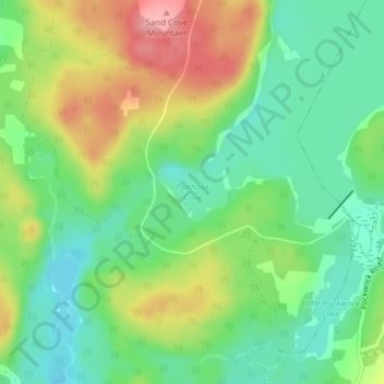
Name: Ponhook Cove topographic map, elevation, terrain.

Location: Ponhook Cove, Head of St. Margarets Bay, Halifax Regional Municipality, Halifax County, Nova Scotia, B4B 1P2, Canada (44.77755 -63.87343 44.77765 -63.87333)

Average elevation: 427 ft

Minimum elevation: 282 ft

Maximum elevation: 646 ft

Other topographic maps

Click on a map to view its topography, its elevation and its terrain.

Gear up for your next adventure:

🚑Emergency Bivvies - Heat-reflective sleeping bags for survival situations
Camping Coffee Makers - Enjoy premium coffee at the summit or campsite
☀️Outdoor Sunscreen - High protection sunscreen for outdoor activities
🌡️Handheld Weather Meters - Measure wind, temp, and pressure for safe mountain travel
🔭Telescopic Hiking Pole - Adjustable pole for hiking stability

As an Amazon Associate, this site earns from qualifying purchases at no extra cost to you.