Geolocate

Pantingan topographic map

Click on the map to display elevation.

About this map

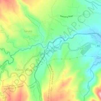
Name: Pantingan topographic map, elevation, terrain.

Location: Pantingan, Balanga, Bataan, Central Luzon, 2101, Philippines (14.61308 120.45904 14.65308 120.49904)

Average elevation: 361 ft

Minimum elevation: 108 ft

Maximum elevation: 768 ft

Other topographic maps

Click on a map to view its topography, its elevation and its terrain.

Cataning

Philippines > Bataan > Balanga

Average elevation: 36 ft

Balanga Wetlands

Philippines > Bataan > Balanga > Tortugas

Average elevation: 7 ft

Bagumbayan

Philippines > Bataan > Balanga

Average elevation: 23 ft

Camacho

Philippines > Bataan > Balanga > Bagong Silang

Average elevation: 72 ft

Cupang West

Philippines > Bataan > Balanga

Average elevation: 30 ft

Dangcol

Philippines > Bataan > Balanga

Average elevation: 502 ft

Tortugas

Philippines > Bataan > Balanga

Average elevation: 3 ft

Talisay River

Philippines > Bataan > Balanga

Average elevation: 7 ft

Dangcol

Philippines > Bataan > Balanga

Average elevation: 502 ft

Camacho

Philippines > Bataan > Balanga

Average elevation: 72 ft

Gear up for your next adventure:

Backpacking Tents - Weight-optimized shelters for multi-day topographic surveys
🧴Hand Sanitizer - Keep hands clean while hiking
🌲Outdoor Survival Books - Best books on survival skills
🦟Ultrasonic Repellers - Create a bug-free zone at your camp or rest stop
🌡️Handheld Weather Meters - Measure wind, temp, and pressure for safe mountain travel

As an Amazon Associate, this site earns from qualifying purchases at no extra cost to you.