Geolocate

Dangcol topographic map

Click on the map to display elevation.

About this map

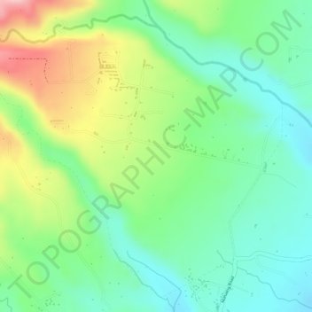
Name: Dangcol topographic map, elevation, terrain.

Location: Dangcol, Balanga, Bataan, Central Luzon, 2100, Philippines (14.64311 120.45540 14.66833 120.48419)

Average elevation: 502 ft

Minimum elevation: 256 ft

Maximum elevation: 906 ft

Other topographic maps

Click on a map to view its topography, its elevation and its terrain.

Sitio Clover

Philippines > Bataan > Balanga

Average elevation: 157 ft

Cabog-cabog

Philippines > Bataan > Balanga

Average elevation: 456 ft

Pantingan

Philippines > Bataan > Balanga

Average elevation: 361 ft

Bagong Silang

Philippines > Bataan > Balanga

Average elevation: 125 ft

Tuyo

Philippines > Bataan > Balanga

Average elevation: 33 ft

Balanga Wetlands

Philippines > Bataan > Balanga > Tortugas

Average elevation: 7 ft

Tortugas

Philippines > Bataan > Balanga

Average elevation: 10 ft

Tortugas

Philippines > Bataan > Balanga

Average elevation: 16 ft

Tuyo

Philippines > Bataan > Balanga

Average elevation: 33 ft

Bagong Silang

Philippines > Bataan > Balanga

Average elevation: 125 ft

Tuyo

Philippines > Bataan > Balanga

Average elevation: 33 ft

Bagong Silang

Philippines > Bataan > Balanga

Average elevation: 125 ft

Gear up for your next adventure:

Solar GPS Watches - Advanced multisport watches with built-in topographic maps
🥤Water Filter Bottle - All‑in‑one filter bottle for safe hydration
🧺Microfiber Travel Towels - Compact and fast-drying towels for trail use
GPS Sports Watch - GPS watch for running, hiking and training
🔥Plasma Lighters - Windproof lighters that work in any weather condition

As an Amazon Associate, this site earns from qualifying purchases at no extra cost to you.