
Make a donation
Gear up for your next adventure:
As an Amazon Associate, this site earns from qualifying purchases at no extra cost to you.
Little Grand Canyon topographic map
Click on the map to display elevation.
Make a donation
Gear up for your next adventure:
As an Amazon Associate, this site earns from qualifying purchases at no extra cost to you.
Little Grand Canyon
Erosion carved this deep box canyon from the sandstone of the Shawnee Hills, opening into the floodplain of the Mississippi River near Turkey Bayou. The canyon contains several seasonal and a few permanent waterfalls, some descending through dramatic cascades of sculpted sandstone. The 3.6-mile (5.8 km) trail is marked by white diamond blazes and begins in the upland hardwood forest. The trail then descends through a steep and sometimes slippery sandstone side canyon to the lusher, damper habitat of the canyon floor. The ascent from the canyon requires a small amount of climbing at the Three Sisters Waterfall. Stone steps on parts of the trail were constructed by the Civilian Conservation Corps, not by Native Americans as some believe. There is an approximate 350-foot (110 m) difference in elevation between the bottom of the canyon and the trailhead. The trailhead facilities include a picnic area and pit toilet. No water is available. Hikers should be aware of unmarked and unguarded cliff edges and the possibility of flash floods during heavy rain.
Make a donation
Gear up for your next adventure:
As an Amazon Associate, this site earns from qualifying purchases at no extra cost to you.
About this map
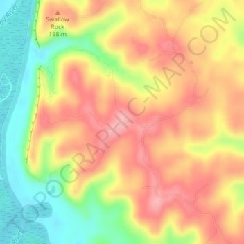
Name: Little Grand Canyon topographic map, elevation, terrain.
Location: Little Grand Canyon, Jackson County, Illinois, United States (37.68048 -89.39550 37.68058 -89.39540)
Average elevation: 551 ft
Minimum elevation: 328 ft
Maximum elevation: 725 ft
Make a donation
Gear up for your next adventure:
As an Amazon Associate, this site earns from qualifying purchases at no extra cost to you.
Other topographic maps
Click on a map to view its topography, its elevation and its terrain.
Make a donation
Gear up for your next adventure:
As an Amazon Associate, this site earns from qualifying purchases at no extra cost to you.
Make a donation
Gear up for your next adventure:
As an Amazon Associate, this site earns from qualifying purchases at no extra cost to you.