
Garden topographic map
Click on the map to display elevation.
About this map
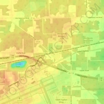
Name: Garden topographic map, elevation, terrain.
Location: Garden, Lucas County, Ohio, United States (41.58422 -83.81633 41.62422 -83.77633)
Average elevation: 669 ft
Minimum elevation: 581 ft
Maximum elevation: 702 ft
Lucas County trails, hiking, mountain biking, running and outdoor activities
Other topographic maps
Click on a map to view its topography, its elevation and its terrain.
Oregon
United States > Ohio > Lucas County
Perhaps the most well-known attraction in Oregon is the Sundance Drive-In, one of the last in the region. Pearson Metropark, within the city limits, and Maumee Bay State Park, have preserved or re-created sections of the original Black Swamp topography and forest. The state park also offers a waterfront resort…
Average elevation: 597 ft