
Thank you for supporting this site ❤️
Make a donation
Make a donation
Gear up for your next adventure:
As an Amazon Associate, this site earns from qualifying purchases at no extra cost to you.
Isolabona topographic map
Click on the map to display elevation.
Thank you for supporting this site ❤️
Make a donation
Make a donation
Gear up for your next adventure:
As an Amazon Associate, this site earns from qualifying purchases at no extra cost to you.
About this map
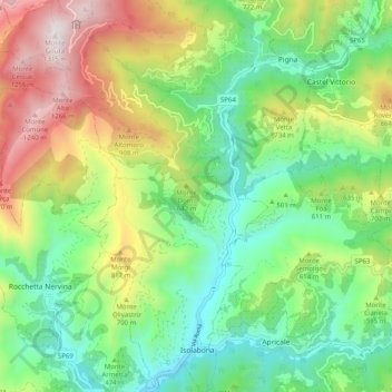
Name: Isolabona topographic map, elevation, terrain.
Location: Isolabona, Imperia, Liguria, Italy (43.87104 7.58845 43.94363 7.67290)
Average elevation: 1,693 ft
Minimum elevation: 266 ft
Maximum elevation: 4,278 ft
Thank you for supporting this site ❤️
Make a donation
Make a donation
Gear up for your next adventure:
As an Amazon Associate, this site earns from qualifying purchases at no extra cost to you.
Other topographic maps
Click on a map to view its topography, its elevation and its terrain.
I Palanchi
Italy > Liguria > Imperia > Ventimiglia > Torri Inferiore > Torri Superiore
Average elevation: 1,001 ft