
Aramoun topographic map
Click on the map to display elevation.
Aramoun
Aramoun (Arabic: عرمون), often referred to as Dawhet Aramoun (Arabic: دوحة عرمون), is a village in the Aley District of Mount Lebanon, Lebanon, lying to the east of Khalde and 22 kilometres away from Beirut. Aramoun's altitude ranges between 250 meters to 600 meters further east. The village has a Druze and Christian community, while the lower town has a majority Sunni Muslim population.
About this map
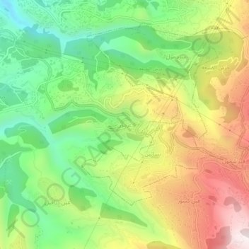
Name: Aramoun topographic map, elevation, terrain.
Location: Aramoun, Aley District, Mount Lebanon Governorate, Lebanon (33.74013 35.50098 33.78013 35.54098)
Average elevation: 1,568 ft
Minimum elevation: 400 ft
Maximum elevation: 3,100 ft
Other topographic maps
Click on a map to view its topography, its elevation and its terrain.
Beirut River
Lebanon > Mount Lebanon Governorate
During the Stone Age, the land on which Beirut is now built was two islands in the delta of the Beirut River, but over the centuries the river silted up and the two islands were connected into one land mass. The right bank of the Beirut River, southwest of the mountain resort town of Beit Mery at an altitude…
Average elevation: 2,047 ft