
Make a donation
Gear up for your next adventure:
As an Amazon Associate, this site earns from qualifying purchases at no extra cost to you.
Beirut River topographic map
Click on the map to display elevation.
Make a donation
Gear up for your next adventure:
As an Amazon Associate, this site earns from qualifying purchases at no extra cost to you.
Beirut River
During the Stone Age, the land on which Beirut is now built was two islands in the delta of the Beirut River, but over the centuries the river silted up and the two islands were connected into one land mass. The right bank of the Beirut River, southwest of the mountain resort town of Beit Mery at an altitude of approximately 125 metres (410 ft) above sea level, is an archaeological site, "Beit Mery I", discovered by Jesuit Father Dillenseger who determined it to be an Acheulean site; the archaeological finds from the site were donated to the French Faculty of Medicine at Saint Joseph University.
Make a donation
Gear up for your next adventure:
As an Amazon Associate, this site earns from qualifying purchases at no extra cost to you.
About this map
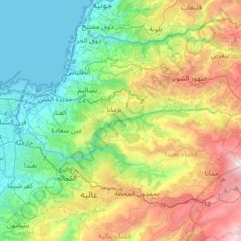
Name: Beirut River topographic map, elevation, terrain.
Average elevation: 2,047 ft
Minimum elevation: -7 ft
Maximum elevation: 6,247 ft
Make a donation
Gear up for your next adventure:
As an Amazon Associate, this site earns from qualifying purchases at no extra cost to you.
Other topographic maps
Click on a map to view its topography, its elevation and its terrain.
Deir Al Qamar
Lebanon > Mount Lebanon Governorate
Deir al-Qamar (Arabic: دَيْر الْقَمَر, romanized: Dayr al-qamar, lit. 'Monastery of the moon') is a city south-east of Beirut in south-central Lebanon. It is located five kilometres outside of Beiteddine in the Chouf District of the Mount Lebanon Governorate at 800 m of average altitude.
Average elevation: 2,474 ft
Aramoun
Lebanon > Mount Lebanon Governorate
Aramoun (Arabic: عرمون), often referred to as Dawhet Aramoun (Arabic: دوحة عرمون), is a village in the Aley District of Mount Lebanon, Lebanon, lying to the east of Khalde and 22 kilometres away from Beirut. Aramoun's altitude ranges between 250 meters to 600 meters further east. The village has…
Average elevation: 1,568 ft
Make a donation
Gear up for your next adventure:
As an Amazon Associate, this site earns from qualifying purchases at no extra cost to you.
Antelias
Lebanon > Mount Lebanon Governorate
The municipality of Antelias - Naqqach is located in the Kaza of Metn in Mount Lebanon, one of the eight mohafazats (governorates) of Lebanon. Antelias - Naqqach is 8 kilometers (4.9712 mi) from Beyrouth (Beirut), the capital of Lebanon. Its elevation is 10 meters (32.81 ft; 10.936 yd) above sea level.…
Average elevation: 646 ft
Make a donation
Gear up for your next adventure:
As an Amazon Associate, this site earns from qualifying purchases at no extra cost to you.
Make a donation
Gear up for your next adventure:
As an Amazon Associate, this site earns from qualifying purchases at no extra cost to you.
Nabay
Lebanon > Mount Lebanon Governorate
Nabay (Arabic: نابيه, from the Aramaic: נביא ; ܢܒܺܝܶ̈ܐ) is a village located in the Matn District (kada), Mount Lebanon Governorate (Mohafazat). Nabay is located 16 kilometers (9.9424 mi) away from the capital Beirut. Its elevation is 500 meters (1640.5 ft - 546.8 yd) above sea level. Nabay…
Average elevation: 1,453 ft
Make a donation
Gear up for your next adventure:
As an Amazon Associate, this site earns from qualifying purchases at no extra cost to you.
Make a donation
Gear up for your next adventure:
As an Amazon Associate, this site earns from qualifying purchases at no extra cost to you.
Make a donation
Gear up for your next adventure:
As an Amazon Associate, this site earns from qualifying purchases at no extra cost to you.