
Make a donation
Gear up for your next adventure:
As an Amazon Associate, this site earns from qualifying purchases at no extra cost to you.
Abu Dis topographic map
Click on the map to display elevation.
Make a donation
Gear up for your next adventure:
As an Amazon Associate, this site earns from qualifying purchases at no extra cost to you.
About this map
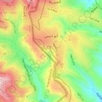
Name: Abu Dis topographic map, elevation, terrain.
Location: Abu Dis, Area B, West Bank, Palestinian Territory (31.75258 35.25176 31.76759 35.27401)
Average elevation: 2,031 ft
Minimum elevation: 1,562 ft
Maximum elevation: 2,490 ft
Make a donation
Gear up for your next adventure:
As an Amazon Associate, this site earns from qualifying purchases at no extra cost to you.
Other topographic maps
Click on a map to view its topography, its elevation and its terrain.
Make a donation
Gear up for your next adventure:
As an Amazon Associate, this site earns from qualifying purchases at no extra cost to you.
Make a donation
Gear up for your next adventure:
As an Amazon Associate, this site earns from qualifying purchases at no extra cost to you.
Make a donation
Gear up for your next adventure:
As an Amazon Associate, this site earns from qualifying purchases at no extra cost to you.
Make a donation
Gear up for your next adventure:
As an Amazon Associate, this site earns from qualifying purchases at no extra cost to you.
Beit Fajjar
Palestinian Territory > Area B
The site's high altitude was the highest point in the area and later the town expanded into other hills. During British rule in Palestine in the 1920s-1940s, Beit Fajjar was used as an observation point for the Bethlehem-Hebron area.
Average elevation: 2,881 ft
Make a donation
Gear up for your next adventure:
As an Amazon Associate, this site earns from qualifying purchases at no extra cost to you.