
City of Moncton topographic map
Click on the map to display elevation.
About this map
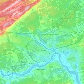
Name: City of Moncton topographic map, elevation, terrain.
Location: City of Moncton, Westmorland County, New Brunswick, Canada (46.04908 -64.92322 46.17578 -64.68658)
Average elevation: 174 ft
Minimum elevation: -3 ft
Maximum elevation: 669 ft
Other topographic maps
Click on a map to view its topography, its elevation and its terrain.
Memramcook Lake
Canada > New Brunswick > Westmorland County > Dorchester Parish
Average elevation: 62 ft
Haute-Aboujagane
Canada > New Brunswick > Westmorland County > Beaubassin East
Average elevation: 92 ft
Johnson's Mills
Canada > New Brunswick > Westmorland County > Johnson's Mills
Average elevation: 79 ft