Geolocate

London topographic map

Click on the map to display elevation.

👉 Easily get elevation data in JSON, GeoTIFF and KML formats using Elevation API
Thank you for supporting this site ❤️
Make a donation

About this map

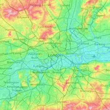
Name: London topographic map, elevation, terrain.

Location: London, Greater London, England, SW1A 2DX, United Kingdom (51.34732 -0.28765 51.66732 0.03235)

Average elevation: 138 ft

Minimum elevation: -10 ft

Maximum elevation: 535 ft

Other topographic maps

Click on a map to view its topography, its elevation and its terrain.

London

United Kingdom > England > London

Average elevation: 253 ft

Hampstead Heath

United Kingdom > England > London

Average elevation: 308 ft

London

United Kingdom > England > London

Average elevation: 69 ft

Plumstead Common

United Kingdom > England > London

Average elevation: 144 ft

Kensington Gardens

United Kingdom > England > London

Average elevation: 82 ft

Pool River

United Kingdom > England > London

Average elevation: 118 ft

Hackney Marshes

United Kingdom > England > London

Average elevation: 33 ft

Harmondsworth Moor

United Kingdom > England > London

Average elevation: 85 ft

Hampstead No. 1 Pond

United Kingdom > England > London

Average elevation: 266 ft

Castlewood

United Kingdom > England > London

Average elevation: 226 ft

Soho Square

United Kingdom > England > London > Islington

Average elevation: 92 ft

Falcon Park

United Kingdom > England > London

Average elevation: 36 ft

Gear up for your next adventure:

🔭Compact Binoculars - HD vision for scouting terrain and identifying distant landmarks
🧭Map Reading Tools - Tools and kits for map navigation
🧤Hiking Gloves - Protective gloves for rugged trails
📻Weather Alert Radios - Stay informed of storm risks while off-the-grid
🪶Multi‑Purpose Knife - Useful blade for camp and trail

As an Amazon Associate, this site earns from qualifying purchases at no extra cost to you.