
Mbombela topographic map
Click on the map to display elevation.
About this map
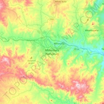
Name: Mbombela topographic map, elevation, terrain.
Average elevation: 2,762 ft
Minimum elevation: 1,617 ft
Maximum elevation: 4,865 ft
Other topographic maps
Click on a map to view its topography, its elevation and its terrain.
Kanyamazane
South Africa > Mpumalanga > Ehlanzeni District Municipality > Mbombela
Average elevation: 2,090 ft
Umjindi Ward 1
South Africa > Mpumalanga > Ehlanzeni District Municipality > Umjindi Local Municipality
Average elevation: 3,005 ft
Marite
South Africa > Mpumalanga > Ehlanzeni District Municipality > Bushbuckridge
Average elevation: 1,975 ft
Klipkoppie Dam
South Africa > Mpumalanga > Ehlanzeni District Municipality > Mbombela
Average elevation: 3,192 ft
Blyde River Canyon Nature Reserve
South Africa > Mpumalanga > Ehlanzeni District Municipality > Thaba Chweu Local Municipality
The Mogologolo (1,794 m), Mariepskop (1,944 m) and Hebronberg (1,767 m) massifs are partially included in the reserve. Elevation varies from 560 m to 1,944 m above sea level. Its resort areas are F.H. Odendaal and Swadeni, the latter only accessible from Limpopo province. The area of approximately 29,000…
Average elevation: 3,412 ft
Lydenburg
South Africa > Mpumalanga > Ehlanzeni District Municipality > Thaba Chweu Local Municipality
Average elevation: 4,672 ft
Kwena Dam
South Africa > Mpumalanga > Ehlanzeni District Municipality > Thaba Chweu Local Municipality
Average elevation: 3,888 ft
Blyde River
South Africa > Mpumalanga > Ehlanzeni District Municipality
The Motlatse River ("Permanent River"), Blyde River (Afrikaans: Blyderivier "Glad River"), or Umdhlazi River is a river in the Mpumalanga and Limpopo provinces of South Africa. It has a northwards course in steep-sided valleys and ravines of the Mpumalanga Drakensberg, before it enters the lowveld region of…
Average elevation: 3,051 ft
Driekoppies Dam
South Africa > Mpumalanga > Ehlanzeni District Municipality > Nkomazi > Schulzendal
Average elevation: 1,165 ft
Manyeleti
South Africa > Mpumalanga > Ehlanzeni District Municipality > Bushbuckridge
Average elevation: 1,234 ft
Thaba Chweu Local Municipality
South Africa > Mpumalanga > Ehlanzeni District Municipality
Average elevation: 3,960 ft
Witklip Dam
South Africa > Mpumalanga > Ehlanzeni District Municipality > Thaba Chweu Local Municipality
Average elevation: 3,438 ft
Sabi Sands Game Reserve
South Africa > Mpumalanga > Ehlanzeni District Municipality > Bushbuckridge
Average elevation: 1,381 ft
Tekwane North
South Africa > Mpumalanga > Ehlanzeni District Municipality > Mbombela
Average elevation: 2,530 ft
Umjindi Local Municipality
South Africa > Mpumalanga > Ehlanzeni District Municipality
Average elevation: 3,304 ft
Tekwane North
South Africa > Mpumalanga > Ehlanzeni District Municipality > Mbombela > eMankayana
Average elevation: 2,530 ft
Kanyamazane
South Africa > Mpumalanga > Ehlanzeni District Municipality > Mbombela
Average elevation: 2,087 ft
Umgwenya
South Africa > Mpumalanga > Ehlanzeni District Municipality > Thaba Chweu Local Municipality
Average elevation: 3,970 ft
Lydenburg
South Africa > Mpumalanga > Ehlanzeni District Municipality > Thaba Chweu Local Municipality
Average elevation: 4,672 ft
Lydenburg
South Africa > Mpumalanga > Ehlanzeni District Municipality > Thaba Chweu Local Municipality
Average elevation: 4,672 ft
Umbabat Nature Reserve
South Africa > Mpumalanga > Ehlanzeni District Municipality > Bushbuckridge
Average elevation: 1,125 ft
Klaserie Private Nature Reserve
South Africa > Mpumalanga > Ehlanzeni District Municipality
Average elevation: 1,296 ft
Umgwenya
South Africa > Mpumalanga > Ehlanzeni District Municipality > Thaba Chweu Local Municipality
Average elevation: 3,973 ft
Thaba Chweu Local Municipality
South Africa > Mpumalanga > Ehlanzeni District Municipality
Average elevation: 3,960 ft
Kwena Dam
South Africa > Mpumalanga > Ehlanzeni District Municipality > Thaba Chweu Local Municipality
Average elevation: 3,888 ft
Marite
South Africa > Mpumalanga > Ehlanzeni District Municipality > Bushbuckridge
Average elevation: 1,975 ft
MalaMala Game Reserve
South Africa > Mpumalanga > Ehlanzeni District Municipality > Bushbuckridge
Average elevation: 1,109 ft
Manyeleti
South Africa > Mpumalanga > Ehlanzeni District Municipality > Bushbuckridge
Average elevation: 1,234 ft
Thaba Chweu Local Municipality
South Africa > Mpumalanga > Ehlanzeni District Municipality
Average elevation: 3,960 ft
Thaba Chweu Local Municipality
South Africa > Mpumalanga > Ehlanzeni District Municipality
Average elevation: 3,960 ft
Umjindi Local Municipality
South Africa > Mpumalanga > Ehlanzeni District Municipality
Average elevation: 3,304 ft
Longmere Dam
South Africa > Mpumalanga > Ehlanzeni District Municipality > Mbombela > White River Country Estates
Average elevation: 3,159 ft
MalaMala Game Reserve
South Africa > Mpumalanga > Ehlanzeni District Municipality > Bushbuckridge
Average elevation: 1,109 ft