
Make a donation
Gear up for your next adventure:
As an Amazon Associate, this site earns from qualifying purchases at no extra cost to you.
Bushbuckridge topographic map
Click on the map to display elevation.
Make a donation
Gear up for your next adventure:
As an Amazon Associate, this site earns from qualifying purchases at no extra cost to you.
About this map
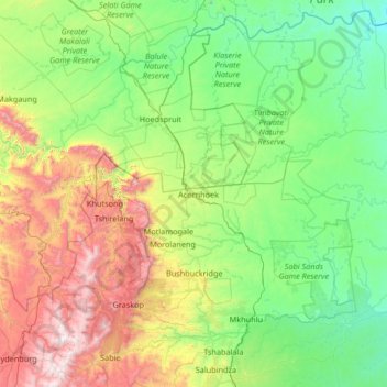
Name: Bushbuckridge topographic map, elevation, terrain.
Average elevation: 2,234 ft
Minimum elevation: 627 ft
Maximum elevation: 7,320 ft
Make a donation
Gear up for your next adventure:
As an Amazon Associate, this site earns from qualifying purchases at no extra cost to you.
Other topographic maps
Click on a map to view its topography, its elevation and its terrain.
Sabie
South Africa > Mpumalanga > Ehlanzeni District Municipality > Thaba Chweu Local Municipality
Average elevation: 3,773 ft
Matsulu
South Africa > Mpumalanga > Ehlanzeni District Municipality > Mbombela
Average elevation: 1,473 ft
Malalane
South Africa > Mpumalanga > Ehlanzeni District Municipality > Nkomazi
Average elevation: 1,155 ft
Sabie
South Africa > Mpumalanga > Ehlanzeni District Municipality > Thaba Chweu Local Municipality
Average elevation: 3,773 ft
Make a donation
Gear up for your next adventure:
As an Amazon Associate, this site earns from qualifying purchases at no extra cost to you.
Witklip Dam
South Africa > Mpumalanga > Ehlanzeni District Municipality > Thaba Chweu Local Municipality
Average elevation: 3,438 ft
The Three Rondavels
South Africa > Mpumalanga > Ehlanzeni District Municipality > Thaba Chweu Local Municipality
The Mogologolo (1,794 m), Mariepskop (1,944 m) and Hebronberg (1,767 m) massifs are partially included in the reserve. Elevation varies from 560 m to 1,944 m above sea level. Its resort areas are F.H. Odendaal and Swadeni, the latter only accessible from Limpopo province. The area of approximately 29,000…
Average elevation: 3,419 ft
Mariepskop
South Africa > Mpumalanga > Ehlanzeni District Municipality > Bushbuckridge
Several distinguishable plant communities have been described. The foothills are covered in low altitude woodlands, which are distinguished as lowveld gallery forest, savanna on mountain slopes, savanna on rocky terrain and submontane forest. In the mountain's higher reaches the high mountain grassland is…
Average elevation: 4,741 ft
Make a donation
Gear up for your next adventure:
As an Amazon Associate, this site earns from qualifying purchases at no extra cost to you.
Sudwala Caves
South Africa > Mpumalanga > Ehlanzeni District Municipality > Mbombela
Average elevation: 3,264 ft
Longmere Dam
South Africa > Mpumalanga > Ehlanzeni District Municipality > Mbombela > White River Country Estates
Average elevation: 3,159 ft
Kwena Dam
South Africa > Mpumalanga > Ehlanzeni District Municipality > Thaba Chweu Local Municipality
Average elevation: 3,888 ft
Make a donation
Gear up for your next adventure:
As an Amazon Associate, this site earns from qualifying purchases at no extra cost to you.
Lydenburg
South Africa > Mpumalanga > Ehlanzeni District Municipality > Thaba Chweu Local Municipality
Average elevation: 4,672 ft
Manyeleti
South Africa > Mpumalanga > Ehlanzeni District Municipality > Bushbuckridge
Average elevation: 1,234 ft
Sudwala Caves
South Africa > Mpumalanga > Ehlanzeni District Municipality > Mbombela
Average elevation: 3,264 ft
Kiepersol
South Africa > Mpumalanga > Ehlanzeni District Municipality > Mbombela
Average elevation: 2,477 ft
Make a donation
Gear up for your next adventure:
As an Amazon Associate, this site earns from qualifying purchases at no extra cost to you.
White River
South Africa > Mpumalanga > Ehlanzeni District Municipality > Mbombela
White River is located in the low altitude subtropical Lowveld climatic zone. Savannah and woodland scattered with granite outcrops form the indigenous habitat. Compared to other parts of South Africa, the climate is mild with good rainfall. Nevertheless, like the rest of South Africa, White River and its…
Average elevation: 2,959 ft
Kamhlushwa
South Africa > Mpumalanga > Ehlanzeni District Municipality > Nkomazi
Average elevation: 833 ft
Make a donation
Gear up for your next adventure:
As an Amazon Associate, this site earns from qualifying purchases at no extra cost to you.
Marloth Park
South Africa > Mpumalanga > Ehlanzeni District Municipality > Nkomazi
Average elevation: 722 ft
Way to Dientjie Falls
South Africa > Mpumalanga > Ehlanzeni District Municipality > Thaba Chweu Local Municipality > Kanana
Average elevation: 3,957 ft
White River
South Africa > Mpumalanga > Ehlanzeni District Municipality > Mbombela
White River is located in the low altitude subtropical Lowveld climatic zone. Savannah and woodland scattered with granite outcrops form the indigenous habitat. Compared to other parts of South Africa, the climate is mild with good rainfall. Nevertheless, like the rest of South Africa, White River and its…
Average elevation: 2,959 ft
Manyeleti
South Africa > Mpumalanga > Ehlanzeni District Municipality > Bushbuckridge
Average elevation: 1,234 ft
Make a donation
Gear up for your next adventure:
As an Amazon Associate, this site earns from qualifying purchases at no extra cost to you.
Marite
South Africa > Mpumalanga > Ehlanzeni District Municipality > Bushbuckridge
Average elevation: 1,975 ft
Driekoppies Dam
South Africa > Mpumalanga > Ehlanzeni District Municipality > Nkomazi > Schulzendal
Average elevation: 1,165 ft
Make a donation
Gear up for your next adventure:
As an Amazon Associate, this site earns from qualifying purchases at no extra cost to you.
Matsulu
South Africa > Mpumalanga > Ehlanzeni District Municipality > Mbombela
Average elevation: 1,473 ft
Tekwane North
South Africa > Mpumalanga > Ehlanzeni District Municipality > Mbombela > eMankayana
Average elevation: 2,530 ft
Berg-en-Dal Rest Camp
South Africa > Mpumalanga > Ehlanzeni District Municipality > Mbombela
Average elevation: 1,309 ft
Kwena Dam
South Africa > Mpumalanga > Ehlanzeni District Municipality > Thaba Chweu Local Municipality
Average elevation: 3,888 ft
Make a donation
Gear up for your next adventure:
As an Amazon Associate, this site earns from qualifying purchases at no extra cost to you.
Hazyview
South Africa > Mpumalanga > Ehlanzeni District Municipality > Mbombela
Average elevation: 1,818 ft
Komatipoort
South Africa > Mpumalanga > Ehlanzeni District Municipality > Nkomazi
Average elevation: 568 ft
Hectorspruit
South Africa > Mpumalanga > Ehlanzeni District Municipality > Nkomazi
Average elevation: 899 ft
Make a donation
Gear up for your next adventure:
As an Amazon Associate, this site earns from qualifying purchases at no extra cost to you.
Komatipoort
South Africa > Mpumalanga > Ehlanzeni District Municipality > Nkomazi
Average elevation: 568 ft
Graskop
South Africa > Mpumalanga > Ehlanzeni District Municipality > Thaba Chweu Local Municipality
Average elevation: 4,544 ft
Lydenburg
South Africa > Mpumalanga > Ehlanzeni District Municipality > Thaba Chweu Local Municipality
Average elevation: 4,672 ft
Make a donation
Gear up for your next adventure:
As an Amazon Associate, this site earns from qualifying purchases at no extra cost to you.
Barberton
South Africa > Mpumalanga > Ehlanzeni District Municipality > Umjindi Local Municipality
Average elevation: 3,009 ft
Crocodile Bridge Rest Camp
South Africa > Mpumalanga > Ehlanzeni District Municipality > Nkomazi
Average elevation: 587 ft
Mopane Dam
South Africa > Mpumalanga > Ehlanzeni District Municipality > Bushbuckridge
Average elevation: 1,106 ft
Mbombela
South Africa > Mpumalanga > Ehlanzeni District Municipality
Nelspruit Airport, located about 9 km (6 mi) south west of the city, is the city's original airport owned and operated by the municipality. There are over a hundred aircraft based at the airport. The majority of the aircraft are privately owned but there are several commercial aircraft based here as well.…
Average elevation: 2,762 ft
Make a donation
Gear up for your next adventure:
As an Amazon Associate, this site earns from qualifying purchases at no extra cost to you.
Satara Rest Camp
South Africa > Mpumalanga > Ehlanzeni District Municipality > Bushbuckridge
Average elevation: 879 ft
Hazyview
South Africa > Mpumalanga > Ehlanzeni District Municipality > Mbombela
Average elevation: 1,818 ft
Kaapsehoop
South Africa > Mpumalanga > Ehlanzeni District Municipality > Mbombela
Average elevation: 4,938 ft
Malalane
South Africa > Mpumalanga > Ehlanzeni District Municipality > Nkomazi
Average elevation: 1,155 ft
Make a donation
Gear up for your next adventure:
As an Amazon Associate, this site earns from qualifying purchases at no extra cost to you.
Skukuza Rest Camp
South Africa > Mpumalanga > Ehlanzeni District Municipality > Mbombela
Average elevation: 925 ft
Khutsong
South Africa > Mpumalanga > Ehlanzeni District Municipality > Thaba Chweu Local Municipality
Average elevation: 4,226 ft
Kamagugu
South Africa > Mpumalanga > Ehlanzeni District Municipality > Mbombela
Average elevation: 2,247 ft
Pilgrim's Rest
South Africa > Mpumalanga > Ehlanzeni District Municipality > Thaba Chweu Local Municipality
Average elevation: 4,436 ft
Make a donation
Gear up for your next adventure:
As an Amazon Associate, this site earns from qualifying purchases at no extra cost to you.
Graskop
South Africa > Mpumalanga > Ehlanzeni District Municipality > Thaba Chweu Local Municipality
Average elevation: 4,544 ft
Komatipoort
South Africa > Mpumalanga > Ehlanzeni District Municipality > Nkomazi
Average elevation: 568 ft
Sabie
South Africa > Mpumalanga > Ehlanzeni District Municipality > Thaba Chweu Local Municipality
Average elevation: 3,773 ft
Make a donation
Gear up for your next adventure:
As an Amazon Associate, this site earns from qualifying purchases at no extra cost to you.
Malalane
South Africa > Mpumalanga > Ehlanzeni District Municipality > Nkomazi
Average elevation: 1,155 ft
Kaapsehoop
South Africa > Mpumalanga > Ehlanzeni District Municipality > Mbombela
Average elevation: 4,938 ft
Sabie
South Africa > Mpumalanga > Ehlanzeni District Municipality > Thaba Chweu Local Municipality
Average elevation: 3,773 ft
Mariepskop
South Africa > Mpumalanga > Ehlanzeni District Municipality > Bushbuckridge
Several distinguishable plant communities have been described. The foothills are covered in low altitude woodlands, which are distinguished as lowveld gallery forest, savanna on mountain slopes, savanna on rocky terrain and submontane forest. In the mountain's higher reaches the high mountain grassland is…
Average elevation: 4,741 ft
Make a donation
Gear up for your next adventure:
As an Amazon Associate, this site earns from qualifying purchases at no extra cost to you.
Hazyview
South Africa > Mpumalanga > Ehlanzeni District Municipality > Mbombela > Hazyview
Average elevation: 1,818 ft
Jeppe's Reef
South Africa > Mpumalanga > Ehlanzeni District Municipality > Nkomazi > Jeppe's Reef
Average elevation: 1,414 ft
Klipkoppie Dam
South Africa > Mpumalanga > Ehlanzeni District Municipality > Mbombela
Average elevation: 3,192 ft
Tshabalala
South Africa > Mpumalanga > Ehlanzeni District Municipality > Mbombela
Average elevation: 1,834 ft
Make a donation
Gear up for your next adventure:
As an Amazon Associate, this site earns from qualifying purchases at no extra cost to you.
Skukuza Rest Camp
South Africa > Mpumalanga > Ehlanzeni District Municipality > Mbombela
Average elevation: 925 ft
Apara
South Africa > Mpumalanga > Ehlanzeni District Municipality > Thaba Chweu Local Municipality
Average elevation: 3,950 ft
Hectorspruit
South Africa > Mpumalanga > Ehlanzeni District Municipality > Nkomazi
Average elevation: 899 ft