Geolocate

St. Martin topographic map

Click on the map to display elevation.

About this map

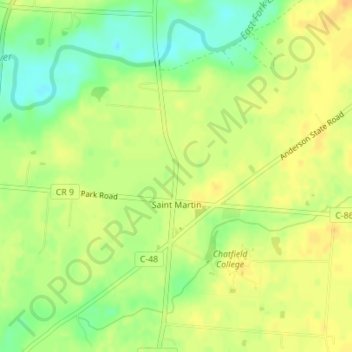
Name: St. Martin topographic map, elevation, terrain.

Location: St. Martin, Brown County, Ohio, United States (39.20439 -83.89615 39.22897 -83.87766)

Average elevation: 971 ft

Minimum elevation: 909 ft

Maximum elevation: 1,010 ft

Brown County trails, hiking, mountain biking, running and outdoor activities

Other topographic maps

Click on a map to view its topography, its elevation and its terrain.

Decatur

United States > Ohio > Brown County

Average elevation: 889 ft

Lake Lorelei

United States > Ohio > Brown County > Vera Cruz

Average elevation: 945 ft

Lake Waynoka

United States > Ohio > Brown County

Average elevation: 1,020 ft

Chasetown

United States > Ohio > Brown County

Average elevation: 945 ft

Vera Cruz

United States > Ohio > Brown County

Average elevation: 928 ft

Gear up for your next adventure:

🧢Outdoor Hiking Hat - Sun protection hat for outdoor explorers
🧢Sun Protection Hats - Wide-brimmed and UPF-rated hats for high-altitude sun safety
🩹Survival Bandages - High‑quality bandages for emergencies
🦟Ultrasonic Repellers - Create a bug-free zone at your camp or rest stop
🗃️Trail First Aid Kit - Essential kit for outdoor injuries and emergencies

As an Amazon Associate, this site earns from qualifying purchases at no extra cost to you.