Geolocate

Hopewell topographic map

Click on the map to display elevation.

About this map

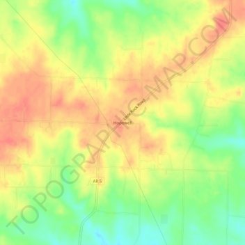
Name: Hopewell topographic map, elevation, terrain.

Location: Hopewell, Cleburne County, Arkansas, United States (35.37814 -92.08515 35.41814 -92.04515)

Average elevation: 833 ft

Minimum elevation: 732 ft

Maximum elevation: 909 ft

Cleburne County trails, hiking, mountain biking, running and outdoor activities

Other topographic maps

Click on a map to view its topography, its elevation and its terrain.

Higden

United States > Arkansas > Cleburne County

Average elevation: 499 ft

Concord

United States > Arkansas > Cleburne County

Average elevation: 974 ft

Gear up for your next adventure:

🧣Merino Neck Gaiters - Multi-functional headwear for wind and sun protection
🧭Outdoor Navigation Book - Learn advanced navigation skills
Solar GPS Watches - Advanced multisport watches with built-in topographic maps
🔌USB Car Charger - Car charger for on‑the‑go power needs
🥾Women's Hiking Boots - Top-rated trail boots with ankle support and superior grip

As an Amazon Associate, this site earns from qualifying purchases at no extra cost to you.