Geolocate

Pontoon topographic map

Click on the map to display elevation.

About this map

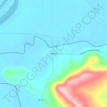
Name: Pontoon topographic map, elevation, terrain.

Location: Pontoon, Conway County, Arkansas, 72025, United States (35.09203 -93.03045 35.13203 -92.99045)

Average elevation: 417 ft

Minimum elevation: 289 ft

Maximum elevation: 1,004 ft

Conway County trails, hiking, mountain biking, running and outdoor activities

Other topographic maps

Click on a map to view its topography, its elevation and its terrain.

Menifee

United States > Arkansas > Conway County

Average elevation: 318 ft

Oppelo

United States > Arkansas > Conway County

Average elevation: 318 ft

Plumerville

United States > Arkansas > Conway County

Average elevation: 348 ft

Morrilton

United States > Arkansas > Conway County

Average elevation: 338 ft

Gear up for your next adventure:

🔊Portable Camp Speaker - Music and alerts at camp
🎒Trail Energy Bars - High‑calorie bars for hiking energy
🦶Hiking Gaiters - Keep debris and water out of your boots
🏔️Mountain Trail Maps - High‑detail maps for popular peaks
🏕️Tent Footprint - Protect your tent base from wear

As an Amazon Associate, this site earns from qualifying purchases at no extra cost to you.