Geolocate

Oppelo topographic map

Click on the map to display elevation.

About this map

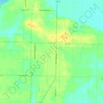
Name: Oppelo topographic map, elevation, terrain.

Location: Oppelo, Conway County, Arkansas, United States (35.07945 -92.80303 35.11580 -92.74760)

Average elevation: 318 ft

Minimum elevation: 272 ft

Maximum elevation: 367 ft

Conway County trails, hiking, mountain biking, running and outdoor activities

Other topographic maps

Click on a map to view its topography, its elevation and its terrain.

Springfield

United States > Arkansas > Conway County

Average elevation: 459 ft

Solgohachia

United States > Arkansas > Conway County

Average elevation: 486 ft

Winrock

United States > Arkansas > Conway County

Average elevation: 722 ft

Pontoon

United States > Arkansas > Conway County

Average elevation: 417 ft

Pleasant Hill

United States > Arkansas > Conway County

Average elevation: 696 ft

Mount Olive

United States > Arkansas > Conway County

Average elevation: 325 ft

Cleveland

United States > Arkansas > Conway County

Average elevation: 659 ft

Jerusalem

United States > Arkansas > Conway County

Average elevation: 725 ft

Hattieville

United States > Arkansas > Conway County

Average elevation: 420 ft

Gear up for your next adventure:

🎒Trekking Poles - Sturdy poles for balance and stability on rough terrain
🗻Climbing Gear Basics - Essential gear for beginner climbers
🏔️Mountain Trail Maps - High‑detail maps for popular peaks
🍳Camping Cook Set - Complete cookware for outdoor meals
🏫Relief Map Kits - Hands-on tools for teaching landforms and elevation

As an Amazon Associate, this site earns from qualifying purchases at no extra cost to you.