
Make a donation
Gear up for your next adventure:
As an Amazon Associate, this site earns from qualifying purchases at no extra cost to you.
Matir topographic map
Click on the map to display elevation.
Make a donation
Gear up for your next adventure:
As an Amazon Associate, this site earns from qualifying purchases at no extra cost to you.
About this map
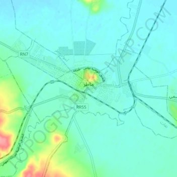
Name: Matir topographic map, elevation, terrain.
Location: Matir, معتمدية ماطر, Bizerte, 7030, Tunisia (37.02429 9.63378 37.04988 9.70543)
Average elevation: 59 ft
Minimum elevation: 13 ft
Maximum elevation: 289 ft
Make a donation
Gear up for your next adventure:
As an Amazon Associate, this site earns from qualifying purchases at no extra cost to you.
Other topographic maps
Click on a map to view its topography, its elevation and its terrain.
Make a donation
Gear up for your next adventure:
As an Amazon Associate, this site earns from qualifying purchases at no extra cost to you.
Bizerte
Tunisia > Bizerte > بوبكر باكير
The bridge leads to the motorway A4 leading to Tunis–Carthage International Airport and the capital. On the town side the P11 passes semi-rural Louata, hugs Ichkeul Lake and branches into a western route, the P7, leading directly to Tabarka on the coast next to the Algerian border. The P11 leads south-west…
Average elevation: 92 ft
Ras Jebel
Tunisia > Bizerte > رأس الجبل الشمالية
Ras Jebel is set on a hill overlooking the Mediterranean Sea. It has an altitude of 53 meters (174 ft).
Average elevation: 203 ft
Make a donation
Gear up for your next adventure:
As an Amazon Associate, this site earns from qualifying purchases at no extra cost to you.