
Make a donation
Gear up for your next adventure:
As an Amazon Associate, this site earns from qualifying purchases at no extra cost to you.
Dulan County topographic map
Click on the map to display elevation.
Make a donation
Gear up for your next adventure:
As an Amazon Associate, this site earns from qualifying purchases at no extra cost to you.
About this map
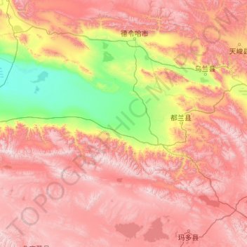
Name: Dulan County topographic map, elevation, terrain.
Average elevation: 12,513 ft
Minimum elevation: 8,783 ft
Maximum elevation: 18,041 ft
Make a donation
Gear up for your next adventure:
As an Amazon Associate, this site earns from qualifying purchases at no extra cost to you.
Other topographic maps
Click on a map to view its topography, its elevation and its terrain.
Xining
China > Qinghai > Renminjie Subdistrict
The city was a commercial hub along the Northern Silk Road's Hexi Corridor for over 2000 years, and was a stronghold of the Han, Sui, Tang, and Song dynasties' resistance against nomadic attacks from the west. Although long a part of Gansu province, Xining was added to Qinghai in 1928. Xining holds sites of…
Average elevation: 8,219 ft
Qaidam Basin
China > Qinghai > Da Qaidam Administrative Zone > Qaidam
Orographically, the Qaidam Basin is a comparatively low area in the northeastern part of the Tibetan Plateau. With an elevation of around 3,000 m (10,000 ft), Qaidam forms a kind of shelf between Tibet to the south (around 4,300 m or 14,000 ft) and Gansu to the north (around 1,100 m or 3,500 ft). A low water…
Average elevation: 8,996 ft
Make a donation
Gear up for your next adventure:
As an Amazon Associate, this site earns from qualifying purchases at no extra cost to you.
Make a donation
Gear up for your next adventure:
As an Amazon Associate, this site earns from qualifying purchases at no extra cost to you.
Make a donation
Gear up for your next adventure:
As an Amazon Associate, this site earns from qualifying purchases at no extra cost to you.
Make a donation
Gear up for your next adventure:
As an Amazon Associate, this site earns from qualifying purchases at no extra cost to you.
Golog Tibetan Autonomous Prefecture
China > Qinghai > Gadê County
The lay of the land of the prefecture is largely determined by the Amne Machin mountain range (max elevation 6,282 m), which runs in the general northwest- to-southeast direction across the entire prefecture, and beyond. The existence of the ridge results in one of the great bends of the Yellow River, which…
Average elevation: 14,239 ft
1m Solar Telescope at 4000m elevation platform, NAOC
China > Qinghai > Mangnai City > Lenghu
Average elevation: 12,881 ft
Make a donation
Gear up for your next adventure:
As an Amazon Associate, this site earns from qualifying purchases at no extra cost to you.
Golog Tibetan Autonomous Prefecture
China > Qinghai > Maqên County > Dawu
The lay of the land of the prefecture is largely determined by the Amne Machin mountain range (max elevation 6,282 m), which runs in the general northwest- to-southeast direction across the entire prefecture, and beyond. The existence of the ridge results in one of the great bends of the Yellow River, which…
Average elevation: 13,455 ft
Hoh Xil
The region covers 83,000 square kilometres at an average elevation of 4,800 metres above sea level, stretches in a meridional (east-west) direction between the Tanggula and Kunlun mountain chains in the border areas of southwest China's Tibet Autonomous Region, northwest China's Qinghai Province and China's…
Average elevation: 15,643 ft
Make a donation
Gear up for your next adventure:
As an Amazon Associate, this site earns from qualifying purchases at no extra cost to you.