
Balfour topographic map
Click on the map to display elevation.
About this map
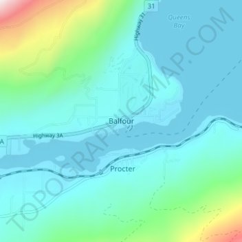
Name: Balfour topographic map, elevation, terrain.
Average elevation: 2,208 ft
Minimum elevation: 1,726 ft
Maximum elevation: 4,774 ft
Other topographic maps
Click on a map to view its topography, its elevation and its terrain.
Ross-White Lady Lake Recreation Site
Canada > British Columbia > Regional District of Central Kootenay > Area E (Balfour/Cottonwood Lake)
Average elevation: 6,096 ft
West Arm Provincial Park
Canada > British Columbia > Regional District of Central Kootenay > Area E (Balfour/Cottonwood Lake)
Average elevation: 4,754 ft
Kokanee Creek
Canada > British Columbia > Regional District of Central Kootenay > Area E (Balfour/Cottonwood Lake)
Average elevation: 6,634 ft
Kokanee Creek Provincial Park
Canada > British Columbia > Regional District of Central Kootenay > Area E (Balfour/Cottonwood Lake)
Average elevation: 2,024 ft