
Cloudland Canyon State Park topographic map
Interactive map
Click on the map to display elevation.
About this map
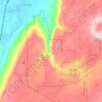
Name: Cloudland Canyon State Park topographic map, elevation, terrain.
Average elevation: 1,601 ft
Minimum elevation: 689 ft
Maximum elevation: 2,234 ft
Cloudland Canyon State Park is a 3,485 acres (14.10 km2) Georgia state park located near Trenton and Cooper Heights on the western edge of Lookout Mountain. One of the largest and most scenic parks in Georgia, it contains rugged geology, and offers visitors a range of vistas across the deep gorge cut through the mountain by Sitton Gulch Creek, where the elevation varies from 800 to over 1,800 feet. Views of the canyon can be seen from the picnic area parking lot, in addition to additional views located along the rim trail. At the bottom of the gorge, two waterfalls cascade across layers of sandstone and shale, ending in small pools below.
Other topographic maps
Click on a map to view its topography, its elevation and its terrain.
Trenton
United States > Georgia > Dade County
Trenton, Dade County, Georgia, United States
Average elevation: 919 ft
West Brow
United States > Georgia > Dade County
West Brow, Dade County, Georgia, 30757, United States
Average elevation: 1,398 ft
Head River
United States > Georgia > Dade County
Head River, Dade County, Georgia, United States
Average elevation: 1,919 ft
Cole City
United States > Georgia > Dade County
Cole City, Dade County, Georgia, United States
Average elevation: 1,414 ft
Rising Fawn
United States > Georgia > Dade County
Rising Fawn, Dade County, Georgia, United States
Average elevation: 1,030 ft
Wildwood
United States > Georgia > Dade County
Wildwood, Dade County, Georgia, 30757, United States
Average elevation: 846 ft
New England
United States > Georgia > Dade County
New England, Dade County, Georgia, United States
Average elevation: 794 ft
New England
United States > Georgia > Dade County
New England, Dade County, Georgia, 30752, United States
Average elevation: 843 ft
Trenton
United States > Georgia > Dade County
Trenton, Dade County, Georgia, United States
Average elevation: 919 ft
Cole City
United States > Georgia > Dade County
Cole City, Dade County, Georgia, United States
Average elevation: 1,368 ft