
Make a donation
Gear up for your next adventure:
As an Amazon Associate, this site earns from qualifying purchases at no extra cost to you.
Faial Island topographic map
Click on the map to display elevation.
Make a donation
Gear up for your next adventure:
As an Amazon Associate, this site earns from qualifying purchases at no extra cost to you.
Faial Island
Faial has a humid subtropical climate with some Mediterranean influences, oceanic at higher altitudes. Average temperature is around 17–18 °C (63–64 °F), 20 °C (68 °F) at daytime and 15 °C (59 °F) at nighttime. It has very mild winters for its latitude, in part due to its location in the mid-Atlantic Ocean and influence from the Gulf Stream, averaging 14 °C (57 °F) in its coldest month, February, and frosts never occur other than at high altitude. For comparison, Ocean City, Maryland, at a similar latitude, is 11.4 °C (52.5 °F) colder in its coldest month, averaging only 2.6 °C (36.7 °F). Summers are warm and relatively dry. Temperatures are moderated year-round, never too hot or too cold, daily temperatures are also moderated, with only 5 °C (41 °F) difference between highs and lows. Average relative humidity remains high at around 80% and insolation is relatively low with around 1800–1900 hours of annual sunshine, similar to locations in coastal northwestern Europe such as Nantes, France, although the sun is stronger in Faial because of its lower latitude. Precipitation is plentiful especially in the winter months, averaging 1,000 mm (39 in) annually. At higher altitudes (e.g. Caldeira Volcano) temperatures are cooler, precipitation and humidity are increasingly higher, and fog is very common.
Make a donation
Gear up for your next adventure:
As an Amazon Associate, this site earns from qualifying purchases at no extra cost to you.
About this map
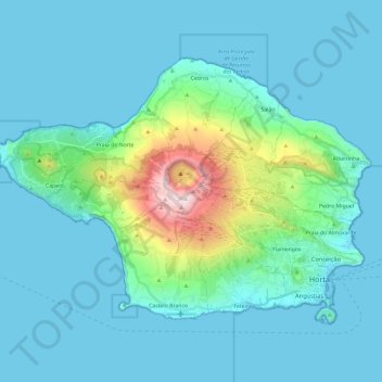
Name: Faial Island topographic map, elevation, terrain.
Location: Faial Island, Azores, Portugal (38.51516 -28.83479 38.64409 -28.59811)
Average elevation: 440 ft
Minimum elevation: 0 ft
Maximum elevation: 3,428 ft
Make a donation
Gear up for your next adventure:
As an Amazon Associate, this site earns from qualifying purchases at no extra cost to you.
Other topographic maps
Click on a map to view its topography, its elevation and its terrain.
Make a donation
Gear up for your next adventure:
As an Amazon Associate, this site earns from qualifying purchases at no extra cost to you.
Braga
The topography in the municipality is characterized by irregular valleys, interspersed by mountainous spaces, fed by rivers running in parallel with the principal rivers. In the north it is limited by the Cávado River, in the south by terrain of the Serra dos Picos to a height of 566 metres (1,857 ft) and…
Average elevation: 669 ft
Make a donation
Gear up for your next adventure:
As an Amazon Associate, this site earns from qualifying purchases at no extra cost to you.
Make a donation
Gear up for your next adventure:
As an Amazon Associate, this site earns from qualifying purchases at no extra cost to you.
Make a donation
Gear up for your next adventure:
As an Amazon Associate, this site earns from qualifying purchases at no extra cost to you.
São Brás de Alportel
Portugal > Faro > São Brás de Alportel > São Brás de Alportel
Average elevation: 833 ft
Make a donation
Gear up for your next adventure:
As an Amazon Associate, this site earns from qualifying purchases at no extra cost to you.
Make a donation
Gear up for your next adventure:
As an Amazon Associate, this site earns from qualifying purchases at no extra cost to you.
Mount Pico
Mount Pico (Portuguese: Montanha do Pico) is a currently dormant stratovolcano located on Pico Island, in the mid-Atlantic archipelago of the Azores. It is the highest mountain in Portugal, at 2,351 metres (7,713 ft) above sea level, and is one of the highest Atlantic mountains; it is more than twice the…
Average elevation: 5,558 ft
Make a donation
Gear up for your next adventure:
As an Amazon Associate, this site earns from qualifying purchases at no extra cost to you.
Ruivo
As the highest point in the archipelago, Pico Ruivo is primarily surrounded by high-altitude heath. The area is also marked by monumental rock formations, which often rise above the clouds, dominating the landscape. The region is home to several bird species, including the Madeira firecrest, the chaffinch, and…
Average elevation: 4,593 ft
Make a donation
Gear up for your next adventure:
As an Amazon Associate, this site earns from qualifying purchases at no extra cost to you.
Relva da Asseiceira
Portugal > Portalegre > Marvão > Santo António das Areias
Average elevation: 1,581 ft
Make a donation
Gear up for your next adventure:
As an Amazon Associate, this site earns from qualifying purchases at no extra cost to you.
Make a donation
Gear up for your next adventure:
As an Amazon Associate, this site earns from qualifying purchases at no extra cost to you.
Beloura
Portugal > Lisbon > Sintra (Santa Maria e São Miguel, São Martinho e São Pedro de Penaferrim)
Average elevation: 597 ft
Make a donation
Gear up for your next adventure:
As an Amazon Associate, this site earns from qualifying purchases at no extra cost to you.
Algarve
The Algarve is located in the southernmost area of continental Portugal and the southwesternmost area of the Iberian Peninsula and mainland Europe, covering an area of 4,997 km2 (1,929 sq mi). It borders to the north with the Alentejo region (Alentejo Litoral and Baixo Alentejo), to the south and west with the…
Average elevation: 236 ft
Make a donation
Gear up for your next adventure:
As an Amazon Associate, this site earns from qualifying purchases at no extra cost to you.
Make a donation
Gear up for your next adventure:
As an Amazon Associate, this site earns from qualifying purchases at no extra cost to you.
Monte Gordo
Portugal > Castelo Branco > Castelo Branco > Santo André das Tojeiras
Average elevation: 935 ft
Make a donation
Gear up for your next adventure:
As an Amazon Associate, this site earns from qualifying purchases at no extra cost to you.
Make a donation
Gear up for your next adventure:
As an Amazon Associate, this site earns from qualifying purchases at no extra cost to you.
Make a donation
Gear up for your next adventure:
As an Amazon Associate, this site earns from qualifying purchases at no extra cost to you.
Make a donation
Gear up for your next adventure:
As an Amazon Associate, this site earns from qualifying purchases at no extra cost to you.
Sintra
Portugal > Lisbon > Sintra (Santa Maria e São Miguel, São Martinho e São Pedro de Penaferrim)
The São João platform, along the northern flank of the Sintra Mountains, has altitudes between 100 metres (110 yd) and 150 metres (160 yd), while the southern part of the mountains, the Cascais platform, is lower: sloping from 150 metres (160 yd) to the sea, terminating along the coast, around 30 metres (33…
Average elevation: 620 ft
Make a donation
Gear up for your next adventure:
As an Amazon Associate, this site earns from qualifying purchases at no extra cost to you.
Make a donation
Gear up for your next adventure:
As an Amazon Associate, this site earns from qualifying purchases at no extra cost to you.
Mount Pico
Mount Pico (Portuguese: Montanha do Pico) is a currently dormant stratovolcano located on Pico Island, in the mid-Atlantic archipelago of the Azores. It is the highest mountain in Portugal, at 2,351 metres (7,713 ft) above sea level, and is one of the highest Atlantic mountains; it is more than twice the…
Average elevation: 5,558 ft
Make a donation
Gear up for your next adventure:
As an Amazon Associate, this site earns from qualifying purchases at no extra cost to you.
Make a donation
Gear up for your next adventure:
As an Amazon Associate, this site earns from qualifying purchases at no extra cost to you.
Cidadelha de Jales
Portugal > Vila Real > Vila Pouca de Aguiar > Alfarela de Jales
Average elevation: 2,569 ft
Make a donation
Gear up for your next adventure:
As an Amazon Associate, this site earns from qualifying purchases at no extra cost to you.
Make a donation
Gear up for your next adventure:
As an Amazon Associate, this site earns from qualifying purchases at no extra cost to you.
Make a donation
Gear up for your next adventure:
As an Amazon Associate, this site earns from qualifying purchases at no extra cost to you.
Make a donation
Gear up for your next adventure:
As an Amazon Associate, this site earns from qualifying purchases at no extra cost to you.