
Make a donation
Gear up for your next adventure:
As an Amazon Associate, this site earns from qualifying purchases at no extra cost to you.
Ballouneh topographic map
Click on the map to display elevation.
Make a donation
Gear up for your next adventure:
As an Amazon Associate, this site earns from qualifying purchases at no extra cost to you.
Ballouneh
Ballouneh (Arabic: بلونة) is a town and municipality in the Keserwan District of the Keserwan-Jbeil Governorate of Lebanon. It is located 18 kilometers north of Beirut. It has an approximate area of 3.93 square kilometers and an average elevation of 650 meters above sea level. Ballouneh's inhabitants are predominantly Maronite Catholics, although Christians from other denominations also live in the town.
Make a donation
Gear up for your next adventure:
As an Amazon Associate, this site earns from qualifying purchases at no extra cost to you.
About this map
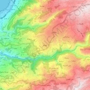
Name: Ballouneh topographic map, elevation, terrain.
Average elevation: 2,133 ft
Minimum elevation: 0 ft
Maximum elevation: 4,088 ft
Make a donation
Gear up for your next adventure:
As an Amazon Associate, this site earns from qualifying purchases at no extra cost to you.
Other topographic maps
Click on a map to view its topography, its elevation and its terrain.
Make a donation
Gear up for your next adventure:
As an Amazon Associate, this site earns from qualifying purchases at no extra cost to you.
Ghazir
Lebanon > Keserwan-Jbeil Governorate
Ghazir (Arabic: غزير) is a town and municipality in the Keserwan District of the Keserwan-Jbeil Governorate of Lebanon. It is located 27 kilometres (17 mi) north of Beirut. It has an average elevation of 380 meters above sea level and a total land area of 542 hectares (2.09 sq mi).
Average elevation: 1,178 ft
Rayfoun
Lebanon > Keserwan-Jbeil Governorate
Rayfoun (Arabic: ريفون; also spelled Reifun or Raifoun) is a village and municipality located in the Keserwan District of the Keserwan-Jbeil Governorate of Lebanon. The village is about 28 kilometres (17 mi) north of Beirut. It has an average elevation of 1,050 meters above sea level and a total land area…
Average elevation: 3,248 ft