
Make a donation
Gear up for your next adventure:
As an Amazon Associate, this site earns from qualifying purchases at no extra cost to you.
Blalock topographic map
Click on the map to display elevation.
Make a donation
Gear up for your next adventure:
As an Amazon Associate, this site earns from qualifying purchases at no extra cost to you.
About this map
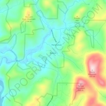
Name: Blalock topographic map, elevation, terrain.
Location: Blalock, Rabun County, Georgia, United States (34.87315 -83.53350 34.91315 -83.49350)
Average elevation: 2,238 ft
Minimum elevation: 1,867 ft
Maximum elevation: 2,999 ft
Rabun County trails, hiking, mountain biking, running and outdoor activities
Make a donation
Gear up for your next adventure:
As an Amazon Associate, this site earns from qualifying purchases at no extra cost to you.
Other topographic maps
Click on a map to view its topography, its elevation and its terrain.
Rabun Gap Nacoochee School Lake Dam
United States > Georgia > Rabun County
Average elevation: 2,201 ft
Tallulah Gorge State Park
United States > Georgia > Rabun County > Tallulah Falls
Average elevation: 1,427 ft
Black Rock Mountain State Park
United States > Georgia > Rabun County > Mountain City
Average elevation: 2,733 ft
Make a donation
Gear up for your next adventure:
As an Amazon Associate, this site earns from qualifying purchases at no extra cost to you.