Geolocate

Hughes Springs topographic map

Click on the map to display elevation.

About this map

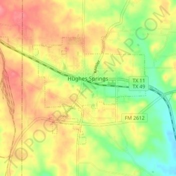
Name: Hughes Springs topographic map, elevation, terrain.

Location: Hughes Springs, Cass County, Texas, 75656, United States (32.97938 -94.66184 33.01207 -94.60119)

Average elevation: 427 ft

Minimum elevation: 292 ft

Maximum elevation: 541 ft

Cass County trails, hiking, mountain biking, running and outdoor activities

Other topographic maps

Click on a map to view its topography, its elevation and its terrain.

Springdale

United States > Texas > Cass County

Average elevation: 276 ft

Avis Dam

United States > Texas > Cass County

Average elevation: 367 ft

Avis Dam

United States > Texas > Cass County

Average elevation: 367 ft

Gear up for your next adventure:

🔭Compact Binoculars - HD vision for scouting terrain and identifying distant landmarks
☀️Outdoor Sunscreen - High protection sunscreen for outdoor activities
🔋Rechargeable Batteries - Power up your outdoor devices
💧Water Purification System - Clean water on the trail with reliable purifiers
🏕️Tent Footprint - Protect your tent base from wear

As an Amazon Associate, this site earns from qualifying purchases at no extra cost to you.