
Make a donation
Gear up for your next adventure:
As an Amazon Associate, this site earns from qualifying purchases at no extra cost to you.
Leawood topographic map
Click on the map to display elevation.
Make a donation
Gear up for your next adventure:
As an Amazon Associate, this site earns from qualifying purchases at no extra cost to you.
About this map
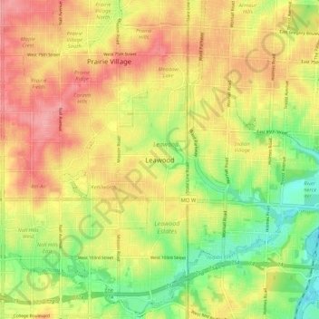
Name: Leawood topographic map, elevation, terrain.
Location: Leawood, Johnson County, Kansas, 64114, United States (38.92667 -94.65690 39.00667 -94.57690)
Average elevation: 938 ft
Minimum elevation: 768 ft
Maximum elevation: 1,089 ft
Johnson County trails, hiking, mountain biking, running and outdoor activities
Make a donation
Gear up for your next adventure:
As an Amazon Associate, this site earns from qualifying purchases at no extra cost to you.
Other topographic maps
Click on a map to view its topography, its elevation and its terrain.
Overland Park Arboretum and Botanical Gardens
United States > Kansas > Johnson County > Overland Park
Average elevation: 1,001 ft
Make a donation
Gear up for your next adventure:
As an Amazon Associate, this site earns from qualifying purchases at no extra cost to you.