
Koninksem topographic map
Click on the map to display elevation.
Koninksem
Koninksem ligt in droog-Haspengouw, nabij de vallei van de Jeker. De hoogte varieert van 90 tot 115 meter.
About this map
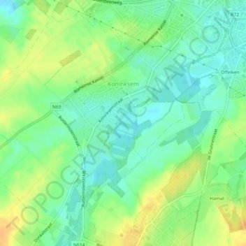
Name: Koninksem topographic map, elevation, terrain.
Location: Koninksem, Tongeren, Limburg, Vlaanderen, België (50.74988 5.40954 50.77571 5.45481)
Average elevation: 322 ft
Minimum elevation: 279 ft
Maximum elevation: 374 ft
Other topographic maps
Click on a map to view its topography, its elevation and its terrain.
Offelken
België > Limburg > Tongeren > Tongeren
Offelken ligt in Droog-Haspengouw. De hoogte varieert tussen 88 en 98 meter. De kern van het gehucht ligt ten zuiden van de aftakking van de Oude Jeker. Deze waterloop werd aangelegd door de mens en heeft een lengte van ongeveer drie kilometer.
Average elevation: 315 ft